Disclosure : This site contains affiliate links to products. We may receive a commission for purchases made through these links.
Sierra Nevada
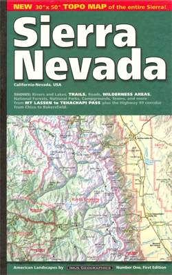
Large attractive map providing an overview of the whole range and its eastern and western approaches, eg the San Joaquin Valley and the desert ranges of Nevada. Coverage extends from California City in the south east to Chico, CA in the west and Eagle Lake, CA in the north. Relief and terrain are depicted by intricate shading, with colours distinguishing, for example, forests, cultivated land, pasture and desert. Many valleys and ranges are named, and other physical features shown include seasonal and perennial rivers and lakes, springs and snowfields. Various protected areas eg. national parks, national forests and wilderness areas are indicated. Spot heights are marked in feet, and symbols depict airports, camp sites, ranger stations, visitor centres, alpine ski areas and wildlife refuges. Railways are omitted but road detail includes many minor roads and makes a distinction between paved and unsurfaced routes. Although this is not intended as a walking map, the major hiking routes such as the John Muir Trail are also marked. Latitude and longitude margin ticks are set at 1ยฐ intervals.

Related Products:
 Sierra Nevada Destination Map
 Nevada Recreational Map
 Nevada Road & Recreation Atlas
 Sierra Nevada – La Alpujarra Editorial Alpina
 Sierra Nevada – the Traverse at 3000m Editorial Piolet
 John Muir Trail – Through the Californian Sierra Nevada
 Hellsgate – Salome & Sierra Ancha Wilderness Areas – Tonto National Forest AZ
 California – Nevada USA 05 Hallwag Road Map
 Sierra Nevada – the Alpujarra – Marquesado del Zenete Editorial Penibetica Map and Guide
 Alpine Lakes Wilderness – Mt Baker-Snoqualmie and Okanogan-Wenatchee National Forests WA
 Banff – Yoho & Kootenay NP Recreation Map & Visitor Guide
 California – Nevada NGS Adventure Map 3119
 Walking and Trekking in the Sierra Nevada: 38 walks, scrambles and multi-day traverses
 Banff National Park Gem Trek
 Pennsylvania Recreation Atlas
 Sierra Nevada Mountain Guidebook
 Utah Benchmark Recreation Map
 Oregon Benchmark Recreational Map
 Sierra Nevada – Las Alpujarras CNIG Map
 Nevada Recreational Atlas & Gazetteer
 Washington State Benchmark Recreation Map
 Oregon
 Sierra Leone ITMB
 Melbourne to Sydney Hema
 Shaver Lake – Sierra National Forest CA
 GR 240: Tour of the Sierra Nevada (Sendero Sulayr)
 Tahoe National Forest – Sierra Buttes / Donner Pass CA
 Salamanca – Sierra de Gredos – Madrid 500K CNIG Regional Map No. 5
 Idaho Benchmark Recreational Map
 Montana Benchmark Road & Recreation Atlas
 Idaho Recreational Map
 Utah Recreational Map
 Colorado Recreational Map
 Oregon Road & Recreation Atlas
 Wyoming Benchmark Road & Recreation Atlas
Oregon Benchmark Road & Recreation Atlas
Wyoming Benchmark Road & Recreation Atlas
Oregon Benchmark Road & Recreation Atlas
 Montana Eastern Recreational Map
 Washington State Road & Recreation Atlas
 Granada & Sierra Nevada