Disclosure : This site contains affiliate links to products. We may receive a commission for purchases made through these links.
Shaftesbury 1900
Shaftesbury in 1900 in a fascinating series of reproductions of old Ordnance Survey plans in the Alan Godfrey Editions, ideal for anyone interested in the history of their neighbourhood or family. The map covers the hill-top town of Shaftesbury. Features include the town centre, Holy Trinity church, High Street, St James, Butts Knap, Hawksdean Lane, St Rumbold`s church, workhouse, Breach Common, Alcester, Castle Hill, Gold Hill, Park Walk, Payne`s Place. Also covered is Bimport, which features in Thomas Hardy`s Jude the Obscure, where Shaftesbury is referred to as Shaston. On the north side of town the map covers Enmore Green and Long Cross.About the Alan Godfrey Editions of the 25″ OS SeriesSelected towns in Great Britain and Ireland are covered by maps showing the extent of urban development in the last decades of the 19th and early 20th century. The plans have been taken from the Ordnance Survey mapping and reprinted at about 15 inches to one mile (1:4,340). On the reverse most maps have historical notes and many also include extracts from contemporary directories. Most maps cover about one mile (1.6kms) north/south, one and a half miles (2.4kms) across; adjoining sheets can be combined to provide wider coverage.FOR MORE INFORMATION AND A COMPLETE LIST OF ALL AVAILABLE TITLES PLEASE CLICK ON THE SERIES LINK.

Related Products:
 Swanage 1900
 March Station 1900
Tamworth 1900
Gillingham (Dorset) 1900
Sturminster Newton 1900
March Station 1900
Tamworth 1900
Gillingham (Dorset) 1900
Sturminster Newton 1900
 Shrewsbury West 1900
Tettenhall 1900
Wimborne Minster 1900
Houghton le Spring 1895
Shrewsbury West 1900
Tettenhall 1900
Wimborne Minster 1900
Houghton le Spring 1895
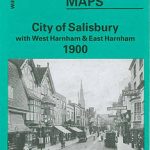 City of Salisbury with West Harnham & East Harnham 1900 – 66.15
Wisbech 1900
Poole 1900
City of Salisbury with West Harnham & East Harnham 1900 – 66.15
Wisbech 1900
Poole 1900
 Lisnaskea, Newtownbutler and The Upper Erne 1900
 Great Driffield 1909
Torquay 1904
Burton on Trent South 1900
Shefford 1900 – 22.12
Central Croydon 1895 – 14.10
Aberdeen 1900 – 75.11
Great Driffield 1909
Torquay 1904
Burton on Trent South 1900
Shefford 1900 – 22.12
Central Croydon 1895 – 14.10
Aberdeen 1900 – 75.11
 Shortlands 1894
Darlington North 1896
Shortlands 1894
Darlington North 1896
 Hunmanby 1926
Denbigh 1910
Knutsford North 1908
Lanark 1896 – 25.15
Criccieth 1913
Hunmanby 1926
Denbigh 1910
Knutsford North 1908
Lanark 1896 – 25.15
Criccieth 1913
 Banbridge 1903
 Castle Bolton, Middleham and Redmire 1910
Bridgnorth 1901
Honiton 1903
Bristol (St George) 1902 – 72.14
North Surbiton and South Kingston 1932
Castle Bolton, Middleham and Redmire 1910
Bridgnorth 1901
Honiton 1903
Bristol (St George) 1902 – 72.14
North Surbiton and South Kingston 1932
 Castle Douglas 1894
 Brandon 1903
Bewdley 1926
Brandon 1903
Bewdley 1926
 Bromley South 1895
Griffin`s Hill 1902
New Quay 1904
Bromley South 1895
Griffin`s Hill 1902
New Quay 1904
 Holywood 1931
Ivybridge 1905
Holywood 1931
Ivybridge 1905