Disclosure : This site contains affiliate links to products. We may receive a commission for purchases made through these links.
Chorley 1909
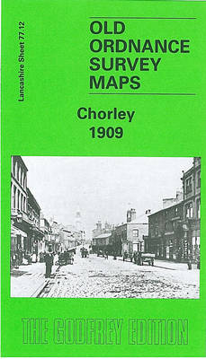
Chorley in 1909 in a fascinating series of reproductions of old Ordnance Survey plans in the Alan Godfrey Editions, ideal for anyone interested in the history of their neighbourhood or family. The map covers the central area of Chorley, extending south and east to Cowling and Limbrick. The town centre is shown in detail and features include railway with station, goods yard and Chorley Wagon Works; Market Place, cattle market, Town Hall, St George`s church, Croft Mill, St George`s Park, Moor Mill, Weldbank Mill, Greenfield Mill, Albert Mills, St James`s church, Lancaster Canal, Cowling Mill, Weir Mill, Workhouse, etc. A directory of private residents is on the reverse. About the Alan Godfrey Editions of the 25″ OS Series:Selected towns in Great Britain and Ireland are covered by maps showing the extent of urban development in the last decades of the 19th and early 20th century. The plans have been taken from the Ordnance Survey mapping and reprinted at about 15 inches to one mile (1:4,340). On the reverse most maps have historical notes and many also include extracts from contemporary directories. Most maps cover about one mile (1.6kms) north/south, one and a half miles (2.4kms) across; adjoining sheets can be combined to provide wider coverage.FOR MORE INFORMATION AND A COMPLETE LIST OF ALL AVAILABLE TITLES PLEASE CLICK ON THE SERIES LINK.

Related Products:
 North Chorley 1909 – 77.08
 Accrington 1909
 Great Driffield 1909
Oswaldtwistle and Church 1909
Padiham 1909
Wrexham Central 1909
Cavan Town 1909
Great Driffield 1909
Oswaldtwistle and Church 1909
Padiham 1909
Wrexham Central 1909
Cavan Town 1909
 Knaresborough 1909
Bexenden 1909
Knaresborough 1909
Bexenden 1909
 Ayr 1909 – 33.06
Rose Grove and Habergham 1909
New Brighton 1909
Lostock Hall and Farington North 1909
Farington South and Leyland North 1909
Wrexham North 1909
Leyland 1909
Blackpool Central Pier 1909
Horbury 1905
Ayr 1909 – 33.06
Rose Grove and Habergham 1909
New Brighton 1909
Lostock Hall and Farington North 1909
Farington South and Leyland North 1909
Wrexham North 1909
Leyland 1909
Blackpool Central Pier 1909
Horbury 1905
 Bromley South 1895
Westhoughton 1907
Bromley South 1895
Westhoughton 1907
 Farnham 1913
Glasgow High Street 1909
Brampton 1924
Honiton 1903
Rhosllanerchrugog 1909
Southport (North) 1909 – 75.06b
Aldershot 1909
Lampeter 1904
Pollok Park 1909
Tranmere & Oxton 1909
Wrexham West 1909
Kidderminster 1921
Farnham 1913
Glasgow High Street 1909
Brampton 1924
Honiton 1903
Rhosllanerchrugog 1909
Southport (North) 1909 – 75.06b
Aldershot 1909
Lampeter 1904
Pollok Park 1909
Tranmere & Oxton 1909
Wrexham West 1909
Kidderminster 1921
 Heywood 1907
 Buckley 1909
 Chelmsford 1919
Denbigh 1910
Govan 1909
Ossett Central 1905
Criccieth 1913
Ossett Central 1890
Chelmsford 1919
Denbigh 1910
Govan 1909
Ossett Central 1905
Criccieth 1913
Ossett Central 1890