Disclosure : This site contains affiliate links to products. We may receive a commission for purchases made through these links.
India Periplus Travel Map
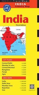
Indian Subcontinent at 1:7,000,000 on an overview map from Periplus, accompanied by enlargements for some of its most visited areas: Rajastan, Goa, and the environs of Delhi and Mumbai, plus street plans of Delhi, Mumbai and Juhu, Panaji, Agra and Bangalore.The main map provides an overview of the Subcontinent, including most of Pakistan, Nepal, Bhutan, Bangladesh and most of Myanmar/Burma, showing the region’s main road and rail connections, plus within India the internal division into states. Some of India’s most visited areas are shown on separate enlargements: the environs of Delhi and Mumbai at 1:200,000, Goa at 1:300,000, plus Rajasthan at 1:2,250,000. The Goa map highlights numerous beaches along its coastline.Large street plans cover central districts of Delhi, Mumbai extending north to the international airport in Juhu and with an enlargement of the city’s central area, plus Agra, Panaji and Bangalore. From all the maps and plans, only the Delhi plan is indexed.


