Disclosure : This site contains affiliate links to products. We may receive a commission for purchases made through these links.
Dominion of Canada c.1900

Related Products:
 Canada Maritime Provinces c.1900
Western Canada Showing Gold Fields c.1900
Canada Maritime Provinces c.1900
Western Canada Showing Gold Fields c.1900
 Central Canada: Manitoba, Saskatchewan & Eastern Ontario c.1900
 Dominion
 Natural Resources Canada North Circumpolar Region Wall Map – Bilingual – Atlas of Canada 1087 x 921 mm
 Dominion: The Making of the Western Mind
 Dominion: A History of England Volume V
 Canada: ITMB/Canada Map Office Topographic Maps of British Columbia and the Rockies
Eastern France c.1900
Canada: ITMB/Canada Map Office Topographic Maps of British Columbia and the Rockies
Eastern France c.1900
 Canada
 Italy around 1900. A Portrait in Color
West of England & Wales c.1900
Italy around 1900. A Portrait in Color
West of England & Wales c.1900
 Flag of Canada
 Flight to Canada
 Canada Wrap
 Granta 141: Canada
 Canada Michelin
 Belonging: The Story of the Jews 1492-1900
South England: Railway Systems c.1900
The Home Counties & the East of England c.1900
Belonging: The Story of the Jews 1492-1900
South England: Railway Systems c.1900
The Home Counties & the East of England c.1900
 Canada – A Concise History
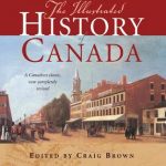 The Illustrated History of Canada
 A Travellers History of Canada
 Canada Western ITMB
 Canada Insight Travel Map
 Living & Working in Canada
 Canada Hand Flag
Northern England and North & Central Scotland c.1900
Canada Hand Flag
Northern England and North & Central Scotland c.1900
 Canada National Parks Wrap
Canada 2022 Desk Calendar
Canada 2022 Wall Calendar
Canada National Parks Wrap
Canada 2022 Desk Calendar
Canada 2022 Wall Calendar
 A City Built Upon The Water: Maritime Bristol 1750-1900
Northern Scotland, Orkney & Shetlands Islands, and the Hebrides c.1900
A City Built Upon The Water: Maritime Bristol 1750-1900
Northern Scotland, Orkney & Shetlands Islands, and the Hebrides c.1900
 CHS Chart 4506 – Plans in the Vicinity of Canada Bay
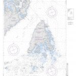
 CHS Chart 4538 – Canada Bay including Chimney Bay
 Planisphere: Latitude 50 N – for Use in the UK and Ireland, Northern Europe and Canada
 The Pacific Crest Trail: Hiking the PCT from Mexico to Canada
 Admiralty Chart 4939 – Canada – British Columbia
 NGA Chart 14061 – Grand Manan New Brunswick Canada
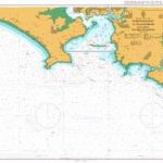 Admiralty Chart 1900 – Whitsand Bay to Yealm Head including Plymouth Sound