Disclosure : This site contains affiliate links to products. We may receive a commission for purchases made through these links.
Dress-Up Jane Austen: Discover History Through Fashion
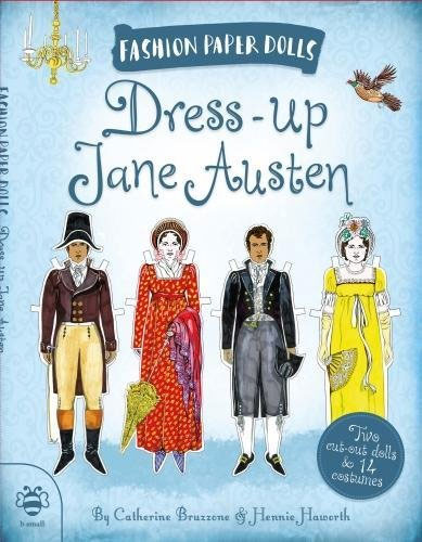
Discover fashion through history! How did a Regency bride and groom dress for their wedding? Why did everyone wear hats? Cut out the fourteen colourful costumes, for both women and men, then dress up the dolls to explore the fashions of Jane Austen`s day.

Related Products:
 Dress-Up Russian Revolution: Discover History Through Fashion
 Rebel Women: Discover history through fashion
 Mother and Daughter Dress-Up Dolls: Costumes From Around the World
 Sticker Dolly Dressing Fashion Long Ago
 Lets Dress!
 The Wit and Wisdom of Jane Austen
 Historical Sticker Dolly Dressing 1930s Fashion
 Talking About Jane Austen in Baghdad
 Sdd Fashion Designer Wedding
 Walking Jane Austen`s London
 Around The World Fashion Sketchbook
 Jane Austen: pocket GIANTS
 A Visitor`s Guide to Jane Austen`s England
 Jane Austen`s England: A Travel Guide
 The Story of Jane Austen: The Girl with the Golden Pen
 Jane Austen Map of London
 Jane Austen, Persuasion
 Dear Jane: Wise Counsel from Ms. Austen and Friends
 Sticker Dolly Dressing – Fashion Designer Autumn & Winter
Jane Austen Persuasion Mini Unl.
Sticker Dolly Dressing – Fashion Designer Autumn & Winter
Jane Austen Persuasion Mini Unl.
 Jane Austen at Home: A Biography
 The Real Jane Austen
 Jane Austen: A Life
 V&A Fashion Mash-Up
 A History of Fashion
 Jane Austen in Bath – Walking Tours in the Writer`s City
 Jane Austen`s England: A Walking Guide
 Sticker Dolly Dressing Fashion Designer New York Collection
The World of Jane Austen: A Jigsaw Puzzle with 60 Characters and Great Houses to Find
Sticker Dolly Dressing Fashion Designer New York Collection
The World of Jane Austen: A Jigsaw Puzzle with 60 Characters and Great Houses to Find
 My Japanese Dolls – Read & Dress
 My Indian Dolls – Read & Dress
 My African Dolls – Read & Dress
 Sticker Dolly Dressing Fashion Designer Spring and Summer Collection
 Sticker Dolly Dressing Fashion Designer Pad
 Let`s Eat!
 Androgyne: Fashion and Gender
 Costumes Around The World
 Mr Darcy`s Guide to Courtship: The Secrets of Seduction from Jane Austen`s Most Eligible Bachelor
 Jane Foster`s Pets
 Sticker Dolly Dressing Fancy Dress