Disclosure : This site contains affiliate links to products. We may receive a commission for purchases made through these links.
Eastern United States Easy-to-Read Rand McNally
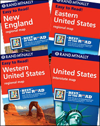
Eastern United States Easy-to-Read map at 1:2,650,000 from Rand McNally presenting the region’s road network on a base highlighting national parks and forests. Numerous enlargements show the areas around main cities in greater detail. Coverage extends to St. Louis, Memphis TN and New Orleans. The index is arranged by state.The enlargements show: Atlanta , Baltimore, Buffalo/Niagara Falls, Boston and vicinity, Cleveland and vicinity, Charlotte, Cincinnati, Columbus, Detroit and vicinity, the Hampton – Norfolk – Chesapeake area, Indianapolis, Louisville, Memphis, Miami and vicinity, Nashville, New York City – Newark area with an extra plan of Manhattan, Orlando, Philadelphia and vicinity, the Raleigh – Durham area, Tampa – St Petersburg, plus Washington DC and vicinity. Also provided is a map with mileage and driving times on main routes across the whole of the US.To see other titles in this series please click on the series link.


