Disclosure : This site contains affiliate links to products. We may receive a commission for purchases made through these links.
The Great Glen Way Map-Guide
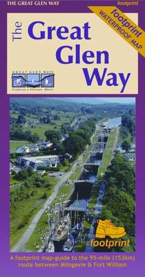
A Footprint map-guide to the 95 mile (153km) route between Milngavie & Fort William. A 1:40,000 scale map based on OS data, printed on waterproof paper with compact and concise information for walkers.
Related Products:
 The West Highland Way – 95 Mile Route Between Milngavie and Fort William
 The C2C Cycle Route – Footprint Map-Guide to the 138 mile Sea to Sea Cycle Route
 The Great Glen Way: Fort William to Inverness Two-Way Trail Guide
 Great Glen Way (Trailblazer British Walking Guide): 38 Large-Scale Maps & Guides to 18 Towns and Villages – Planning, Places to Stay, Places to Eat – Fort William to Inverness
 The Speyside Way – Newtonmore to Buckie
 Great Glen Way Rucksack Reader
 Great Glen Way Harvey National Trail XT40
 Day Walks in Fort William & Glen Coe
 Fort William and Glen Coe
 The Cateran Trail: Blairgowrie – Glen Shee – Glen Isla – Alyth
 Ben Nevis – Fort William & Glen Coe OS Landranger 41
 West Highland Way – Easy-to-use Folding Map and Essential Information
 The West Highland Way: Milngavie to Fort William Scottish Long Distance Route
 West Highland Way Harvey National Trail XT40
 Ben Nevis – Fort William & Glen Coe OS Landranger 41 ACTIVE
 Great Glen Way Cicerone Map Booklet
 Explore Fort William Map: Waterproof Map and Guide
 Fort Augustus, Glen Albyn & Glen Roy OS Landranger Map 34 (paper)
 Fort Augustus, Glen Albyn & Glen Roy OS Landranger Active Map 34 (waterproof)
 Great Britain: Footprint Maps of Long-distance Hiking Routes
 Corbetts Walking Vol 1: South of the Great Glen
 Great Britain: Footprint Maps of Long-distance Cycling Routes
 Ben Nevis, Fort William & Glen Coe OS Landranger Active Map 41 (waterproof)
 Oban to Inverness Cycle Route Map
 The Fife Coastal Path – Kincardine to Newburgh
 Corbetts Walking Vol 2 – North of the Great Glen
 The Cumbria Way
 The West Highland Way: The Official Guide
 Glen Coe & Glen Etive – Ballachulish & Kinlochleven OS Explorer Active Map 384 (waterproof)
 Glen Cassley & Glen Oykel OS Explorer Active Map 440 (waterproof)
 Glen Affric & Glen Moriston – Cannich OS Explorer Active Map 415 (waterproof)
 Glen Coe & Glen Etive – Ballachulish & Kinlochleven OS Explorer Map 384 (paper)
 Glen Affric & Glen Moriston – Cannich OS Explorer Map 415 (paper)
 Glen Cassley & Glen Oykel OS Explorer Map 440 (paper)
 Great Glen & Loch Ness 110K Sustrans Cycle Map No. 47
 West Highland Way Cicerone Map Booklet
 Glen Esk & Glen Tanar – Aboyne & Mount Keen OS Explorer Map OL54 (paper)
 Glen Esk & Glen Tanar – Aboyne & Mount Keen OS Explorer Active Map OL54 (waterproof)
 Lochnagar, Glen Muick & Glen Clova – Ballater & Balmoral OS Explorer Map OL53 (paper)
 Lochnagar, Glen Muick & Glen Clova – Ballater & Balmoral OS Explorer Active Map OL53(waterproof)


