Disclosure : This site contains affiliate links to products. We may receive a commission for purchases made through these links.
Hamm 1945 British War Office Survey Map
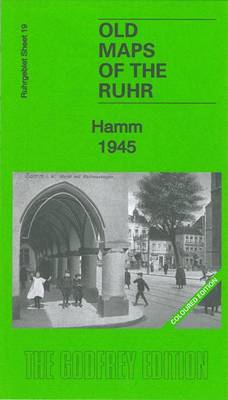
Hamm in 1945 in the Alan Godfrey series of reproductions of British War Office survey first published in 1945 prior to the Allied occupation of the area. Features include city centre, station with railway and marshalling yards, and a key to the major industries and public buildings.To see other titles in this series please click on the series link.This series of reproductions from Alan Godfrey covers the major industrial area east of the Rhine that includes Bochum, Cologne, Dortmund, Duisburg, Dรผsseldorf, Essen, Gelsenkirchen, Oberhausen and other towns, with their great network of railways and industries. The maps are taken from the British War Office 1:12,500 plans and reduced at approximately 1:19,000. Published in 1945, prior to the Allied occupation of the area, the maps are especially good at showing industry, collieries and transport. They are not bombing maps – indeed, they make clear that allowance is not made for bomb damage – but show the areas with all their industrial sites and railways largely as they were before the bombing raids of 1943-44. The maps have additional information added by British intelligence. This is normally accurate but allowance must be made for the `fog of war` and occasional spelling mistakes, etc. Each title has on the reverse a specially written introduction to the area in English, with a shorter text in German. Map legend is in English only.

Related Products:
 Wuppertal: Elberfeld 1945 British War Office Survey Map
 Wuppertal: Barmen 1945 British War Office Survey Map
 Hagen 1944 British War Office Survey Map
 Germany: Alan Godfrey Reproductions of British War Office WWII Maps of the Rhineland
 Hohensyburg and Westhofen 1944 British War Office Survey Map
 Duisburg North: Hamborn and Bruckhausen 1944 British War Office Survey Map
 Dortmund North 1944 British War Office Survey Map
 Koln (N) 1944: Cologne Sheet 1
 Koln (S) 1944: Cologne Sheet 2
 The MET Office Book of the British Weather
 The British Cruise Ship: An Illustrated History 1945-2014
 British Isles Since 1945
 Canada: ITMB/Canada Map Office Topographic Maps of British Columbia and the Rockies
 Mapping the Second World War: The History of the War Through Maps from 1939 to 1945
 Nearly the New World: The British West Indies and the Flight from Nazism, 1933-1945
 The Model Occupation: The Channel Islands Under German Rule, 1940-1945
 Reshaping of British Railways
 Great Britain: Godfrey Editions of Historical Ordnance Survey “A Yard to the Mile” City Plans
 Year Zero: A History of 1945
 Great Britain: Godfrey Editions of Historical Ordnance Survey Inch to a Mile Maps of England & Wales
 Great British Railway Journeys
 London 1945-1948
 ABC British Railway Atlas
 Great Britain and Ireland: Godfrey Editions of Historical Ordnance Survey 25″ Street Plans
Polar Region: British Antarctic Survey`s General Interest Maps
Great Britain and Ireland: Godfrey Editions of Historical Ordnance Survey 25″ Street Plans
Polar Region: British Antarctic Survey`s General Interest Maps
 Wroclaw and Environs pre and post 1945
 The Berlin Diaries 1940-1945
 Road to Liberty 1944/1945 Michelin Map
 France: Alan Godfrey Reproductions of the GSGS Bigot Plans for the D-Day Landings
 Italy World War II 1940-1945 Edizioni Multigraphic Map
 The Regional Office is Under Attack!
 Postwar: A History of Europe Since 1945
 Images of Lost London 1875-1945
 British Railways Atlas 1947 and RCH Junction Diagrams
 Boots on the Ground: Britain and Her Army Since 1945
South Dartmoor and the South Hams 1909
Boots on the Ground: Britain and Her Army Since 1945
South Dartmoor and the South Hams 1909
 Swansong 1945: A Collective Diary from Hitler`s Last Birthday to Ve Day
 The Ordnance Survey Great British Treasure Hunt: Solve the Clues on a Puzzle Adventure
 British Isles: Industries & Communications c.1900
NW Monmouthshire 1914 – 232
British Isles: Industries & Communications c.1900
NW Monmouthshire 1914 – 232