Disclosure : This site contains affiliate links to products. We may receive a commission for purchases made through these links.
East and West
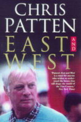
In June of 1997, over a century and a half of British rule in Hong Kong came to an end. Chris Patten writes about his experiences as the last governor of the colony of Hong Kong. He explains why he adopted the stance that he did, and how he fought his battles.

Related Products:
 Not Quite the Diplomat
 Hong Kong – Culture Smart!
 Hong Kong Convention, 2013 English Edition
 Hong Kong Convention, 2013 Arabic Edition
 City on Fire: The Fight for Hong Kong
 Hong Kong Precincts: A Curated Guide to the City`s Best Shops, Eateries, Bars and Other Hangouts
 Trope Hong Kong
 Hong Kong Local: Cult recipes from the streets that make the city
 Hong Kong
 Marguerite Patten`s Century of British Cooking
 The Cold War: A New Oral History of Life Between East and West
 Live & Work In Hong Kong
 Hong Kong & Macau Periplus Travel Map
 Hong Kong Convention – E-Reader
 111 Places in Hong Kong That You Shouldn`t Miss
 Hong Kong PopOut
 A Naturalist`s Guide to the Birds of the Hong Kong (2nd ed)
 The Monocle Travel Guide to Hong Kong (Updated Version)
 Ten Cities That Made an Empire
 Exciting Times
 Once Upon a Hong Kong (Bilingual edition)
 Insight Guides Explore Hong Kong – The Best Routes Around the City
 Hong Kong Nelles
 The Honourable Company: History of the English East India Company
 Enchanting Hong Kong (2nd edition)
 Flag of Hong Kong (New Flag)
 Hong Kong & Region ITMB
 DK Eyewitness Top 10 Hong Kong
 How to Hong Kong: An Illustrated Travel Journal
 Hong-Kong – A Walking Tour
 Berlitz Pocket Guide Hong Kong
 Insight Guides Pocket Hong Kong
 Hong Kong 20/20: Reflections on a Borrowed Place
 Insight Guides Experience Hong Kong
 Shop Cats of Hong Kong
 China & Tibet with Hong Kong Inset c.1900
 Hong Kong Noir
 Thailand: History, Politics and the Rule of Law
 Hong Kong Marco Polo City Map
 Hong Kong Marco Polo Pocket Guide