Disclosure : This site contains affiliate links to products. We may receive a commission for purchases made through these links.
Tsum Valley Trekking Map
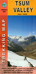
Tsum Valley in central Nepal on an indexed contoured map at 1:100,000 from Shangri-La Design highlighting local trekking routes and places of interest, etc. Coverage extends roughly from the Budhi Gandaki River in the west across the eastern part of the Manaslu Conservation area, to just beyond Dunche in the east.Topography is shown by contours at 40m intervals, plus colouring for woodlands, cultivated areas, glaciers, etc. The map shows local roads and distinguished between main trekking routes and minor trails. An overprint indicates various facilities in local villages, campsites, monasteries and other religious buildings, etc. The map is indexed for places, peaks and passes and had latitude and longitude margin ticks at 5’ intervals. Map legend includes English.Addition information provided on the map or on its cover includes a table with relative oxygen rates at different altitudes, elevation profiles and hiking times for three main routes, plus general information about the area. All the text is in English.


