Disclosure : This site contains affiliate links to products. We may receive a commission for purchases made through these links.
Hungary Pocket Road Atlas SPIRAL-BOUND
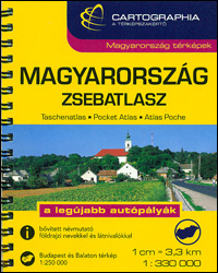
Pocket spiral-bound Road Atlas of Hungary from the Budapest based Cartographia, presenting the country at 1:330,000, with enlargements for the environs of the capital and for Lake Balaton, a distance table and diagrams of motorway interchanges.The atlas shows Hungary at a scale slightly better than used in most folded maps of the country. The number of place names, presentation of the topography and of the road and rail networks is the same as in the publishers’ road atlas at 1:250,000 in an A5 format, but simply reduce in print size. This pocket version does not, however, indicate locations of petrol and LPG stations. Picturesque locations are prominently highlighted and symbols indicate campsites, youth hostels and various interesting sites. The maps have no geographical coordinates. The index includes names of geographical features and places of interest. Map legend includes English.The atlas also contains enlargements showing in greater clarity at 1:250,000 the environs of Budapest and Lake Balaton, a comprehensive distance table, plus over 50 diagrams of motorway junctions.


