Disclosure : This site contains affiliate links to products. We may receive a commission for purchases made through these links.
Skopelos Terrain Editions 320
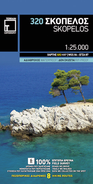
Skopelos at 1:25,000 on a contoured, GPS compatible map published by Terrain Editions, printed on light, waterproof and tear-resistant synthetic paper. Beaches indicate their surface and facilities. All place names are shown in both Greek and Latin alphabet. On the reverse are brief descriptions of seven hiking trails, plus general information about the island, illustrated with colour photos. Map legend and all the text include English.Maps of the Greek islands from Terrain Editions have topography well presented by contours at 20m intervals, enhanced by spot heights, subtle relief shading and additional altitude colouring. Road network is very clearly graded according to width and the type of surface, distinguishing between good and rough dirt roads. Distances are marked on most small local roads, as well as locations of petrol stations and/or tyre repair workshops; scenic routes are highlighted. Each map also shows which ports are served by ferry services. Hiking paths are graded as main or narrow trails. National parks and other protected areas are marked and a wide range of symbols indicate various places of interest and recreational facilities, with main sights clearly highlighted. Most titles distinguish between sandy and pebble beaches; some also indicate beaches with natural shade and/or the type of sea bed. The maps have a UTM grid, plus latitude and longitude margin ticks.The reverse side of each title is covered by general information about the island, illustrated with colour photos. Many titles also include brief descriptions of recommended hiking trails and/or a street plan of the island’s main town, with colouring clearly showing various tourist facilities.

Related Products:
 Sikinos Terrain Editions 317
 Psara Terrain Editions 329
 Skiathos Terrain Editions 319
 Kythira Terrain Editions 346
 Samothrace Terrain Editions 324 SUPERCEDED
 Thasos Terrain Editions 323
 Ikaria Terrain Editions 332
 Ios Terrain Editions 315
 Symi Terrain Editions 341
 Donousa 15K Terrain Editions Pocket Map
 Anafi Terrain Editions 318
 Folegandros Terrain Editions 316
 Tinos Terrain Editions 308
 Syros Terrain Editions 305
 Sifnos Terrain Editions 304
 Tilos Terrain Editions 340
 Nisyros Terrain Editions 339
 Skyros Terrain Editions 322
 Serifos Terrain Editions 303
 Kea / Tzia Terrain Editions 301
 Milos – Kimolos – Polyeghos Terrain Editions 306
 Heraklia 15K Terrain Editions Pocket Map
 Kalymnos Terrain Editions 337
 Chios Terrain Editions 328
 Hydra Terrain Editions 359
 Santorini Terrain Editions 313
 Naxos Terrain Editions 311
Samos Terrain Editions 331
Naxos Terrain Editions 311
Samos Terrain Editions 331
 Samos Terrain Editions 331 SUPERCEDED
 Kos Terrain Editions Map 338
 Kythnos Terrain Editions 302
 Leros Terrain Editions 336
Andros Terrain Editions 307
Leros Terrain Editions 336
Andros Terrain Editions 307
 Astypalaea / Astypalaia Terrain Editions 330
 Koufonisia 15K Terrain Editions Pocket Map
 Alonissos Terrain Editions 321
 Lemnos Terrain Editions 325
 Karpathos – Kasos Terrain Editions 345
 Kimolos & Polyaigos 25K Terrain Editions Pocket Map
 Arki – Lipsi – Aghathonisi Terrain Editions 334