Disclosure : This site contains affiliate links to products. We may receive a commission for purchases made through these links.
Taygetos – North Taygetos Anavasi 8.1
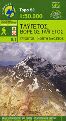
The Taygetos range between Sparta and Kalamata at 1:50,000 on a contoured, GPS compatible map from Anavasi with on the reverse a special map highlighting the region’s numerous hiking trails, including the course of the E4 European long-distance path.On one side is the main map of the area with excellent presentation of its topography by altitude colouring, contours at 20m intervals and plenty of names of peaks, etc. Road network indicates dirt roads in poor condition and difficult or impassable sections. Driving distances are shown on main and many local routes and petrol stations are marked. The marking for footpaths distinguishes between waymarked, well defined, narrow and faint paths. Symbols highlight various places of interest including campsites and hostels, archaeological and historical sites, beaches, areas for climbing, canyoning and paragliding, etc. This revised edition published in late 2012 also indicates fire lanes and firefighting water tanks. The map is indexed and has a 1-km UTM grid plus latitude and longitude crosshairs. On the reverse the same area is shown on a simplified base to highlight the region’s numerous waymarked hiking paths. Also provided here are route profiles of the Taygetos sections of the E4 and the Greek No. 32 long-distance trails.Place names are shown both Greek and Latin alphabets. Map legend and all the text include English.


