Disclosure : This site contains affiliate links to products. We may receive a commission for purchases made through these links.
Greece Anavasi Road Map
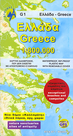
Greece at 1:800,000 on a double-sided, waterproof and tear-resistant map from Anavasi, including a separate index booklet providing lists of protected areas, archaeological sites, ski resorts, etc., all in both Greek and Latin alphabets.The map divides the country north/south. On one side is the mainland with northern Aegean and the Peloponnese just short of Sparta; the reverse side has the islands south of the Sporades and Lesbos (so Evia, the Cyclades, the Dodecanese and Crete), most of the Peloponnese (without its north-west corner beyond Pirgos) and the southernmost part of the mainland including Athens and Delphi.Place names (other than those of administrative municipalities and some mountains) are given in both Greek and Latin alphabets. Bold relief shading shows the country’s topography, with names of mountain ranges and peaks. National parks and other protected areas are highlighted.Road network distinguishes between asphalted and unsurfaces local roads and indicates driving distances on principal routes. Railway and ferry routes are included and local airports are marked. A range of symbols highlight various places of interest, including archaeological sites, byzantine monasteries, castles or fortifications, etc. The map also indicates the country’s best beaches and shows locations of campsites. The map has a UTM grid, although the lines are not always easy to see on land areas. Map legend includes English. The index booklet is in a detachable protective map cover and provides in both Greek and Latin alphabets: a comprehensive table of driving distances; distances in nautical miles from main ports to popular islands; a b/w map of the country indicating locations of national parts and other protected nature areas; extensive lists of ski resorts and archaeological sites cross-referenced to the map. There is also an index of municipalities rather than a full index of all towns and villages shown on the map.


