Disclosure : This site contains affiliate links to products. We may receive a commission for purchases made through these links.
Egina / Aegina Orama Editions 338
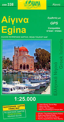
Aegina on a detailed map at 1:25,000 from the Greek publishers Orama Editions, with a large street plan of Aegina Town, bilingual notes on the island’s history, sights and beaches, a list of hotels, etc.The map of the island presents its topography by contours at 20m intervals enhanced by relief shading. All place names are in both Greek and Latin alphabets. Road network indicates dirt roads and shows driving distances on main routes plus locations of petrol stations. Also marked are local paths and hiking trails, as well as ferry connections to Piraeus and other islands, including the nearby Moni. Places of interest are highlighted, including archaeological sites, beaches, etc. The remaining half of the sheet includes: a large street plan of Aegina Town at 1:4,200, with street names in both scripts and a dual index; bilingual notes on the island’s history, sights and beaches; a plan of the archaeological site at Afea (Aphaia/Aphaea); plus a list of hotels. Map legend and all the text include English.

Related Products:
 Corfu Orama Editions 302
 Astypalea / Astypalaia Orama Editions 322
 Skopelos Orama Editions 348
 Zakynthos Terrain Editions 355
 Chalkidiki / Halkidiki – Thessaloniki Street Plan Terrain Editions 412
 Spetses Terrain Editions 360
 Hydra Terrain Editions 359
 Crete Terrain Editions Regional Map 7
 Crete: Rethymno Prefecture 150K Terrain Editions Map
 Argo-Saronic: Salamis, Aegina, Angistri, Poros, Hydra and Spetses
 Crete: Lasithi Prefecture 150K Terrain Editions Map
 Heraklia 15K Terrain Editions Pocket Map
 Kos Terrain Editions Map 338
 Crere: Heraklion Prefecture 150K Terrain Editions Map
 Ikaria Terrain Editions 332
 Crete: Chania Prefecture 150K Terrain Editions Map
 Koufonisia 15K Terrain Editions Pocket Map
 Chios Terrain Editions 328
 Kalymnos Terrain Editions 337
 Mykonos – Delos – Rinia Terrain Editions 309
 Kimolos & Polyaigos 25K Terrain Editions Pocket Map
 Donousa 15K Terrain Editions Pocket Map
 Folegandros Terrain Editions 316
 Kythira Terrain Editions 346
 Anafi Terrain Editions 318
 Greece: Terrain Editions 150K Road Maps of Crete
 Greece: Terrain Editions 100K Touring Maps of Crete
 Thasos Geopsis 214
 Kythnos Terrain Editions 302
 Rhodes Kompass 248
 Aegina: 2016
 Ios Terrain Editions 315
 Eastern Crete Terrain Editions 450
 Arki – Lipsi – Aghathonisi Terrain Editions 334
 Western Crete Terrain Editions 448
Andros Terrain Editions 307
Western Crete Terrain Editions 448
Andros Terrain Editions 307
 Kea / Tzia Terrain Editions 301
 Thasos Terrain Editions 323