Disclosure : This site contains affiliate links to products. We may receive a commission for purchases made through these links.
Rรญo Los Cipreses National Reserve
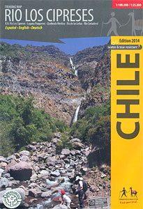
Rรญo Los Cipreses National Reserve on a waterproof and tear-resistant map from Trekkingchile presenting the whole Reserve at 1:100,000, plus its northern part in more detail on an enlargement at 1:25,000. Coverage of the main 100K map extends from El Manzanal southwards to the glaciers around the Cerro Alto de los Arrieros. Contours are at 100m intervals, with colouring/graphics indicating different types of terrain and vegetation (forest, scrubland, pastures, boulder fields, etc). Main trekking routes are highlighted, along with areas for more walks, campsites and bivouacking places, viewpoints, petroglyphs, and other places of interest. The map has a UTM grid plus latitude and longitude margin ticks at 5’ intervals.On the reverse the northern part of the Reserve is shown in greater detail at 1:25,000, with contour lines at 50m intervals. A small panel covers the area around the Agua de la Vida and Agua de la Muerte lakes at 1:10,000. Also included are lively drawings of the local birds and mamals.Maps in the Trekkingchile series use satellite imagery as a base, with contour lines and colouring to indicate different types of terrain and habitats. Unless indicated to the contrary in the individual descriptions, the maps have a UTM grid, plus margin ticks for latitude and longitude. The maps are annotated with tourist information and most titles include a street plan of the region’s main town. Many are illustrated with drawings of local fauna or flora. Map legends and other text include English.To see the other titles in this series please click on the series link


