Disclosure : This site contains affiliate links to products. We may receive a commission for purchases made through these links.
Gooi & Vechtstreek: Hilversum – Amersfoort – Utrecht
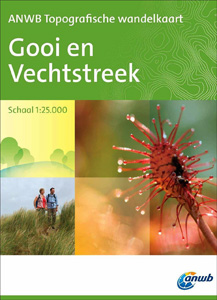
Gooi and Vechtstreek – a popular hiking area south-east of Amsterdam – on a light, double-sided, waterproof and tear-resistant, GPS-compatible maps at 1:25,000 from ANWB, the country’s main motoring and touring organization. Coverage on the northern side extends southwards from the historic town of Naarden, and west/east between the Amsterdam-Rhine Canal and Baarn; the southern side presents the area between Utrecht and Amersfoort. Current 2015 edition of this title does not yet show the network of junctions and waymarked routes.Maps in the series have contours at 2.5 or 5m intervals with spot heights, and show all the topographic features and landmarks expected of survey mapping at this scale. Unusually for a topographic survey, the maps also have colouring and/or graphics to show 14 different types of vegetation or land use (heath, dunes, marshland, orchards, arable land, etc). Where already established on the ground, an overprint highlights the national network of numbered junctions joined by waymarked connecting trails in either direction – a system which enables hikers to plan their own routes. Also marked are locations of TOPs where one can leave the car. Each map covers an area of approx. 12 x 26kms, with an overlap between the sides. The maps have the lines of the Dutch National Grid at intervals of 1km. Map legend, with an extensive list of the various topographic features and landmarks, includes English. To see the list of titles already published in this series please click on the series link.

Related Products:
 Utrecht Hills – `t Gooi – Vecht area Falkplan Cycling Map 12
 Netherlands: ANWB 25K Topographic Survey Hiking Maps
 Sallandse Heuvelrug National Park: Deventer – Raalte – Rijssen
 Vinkeveense Plassen – `t Gooi – Naarden – Hilversum ANWB Hiking Region Map
Utrecht Hill Ridge – Amersfoort ANWB Cycling Map 23
Vinkeveense Plassen – `t Gooi – Naarden – Hilversum ANWB Hiking Region Map
Utrecht Hill Ridge – Amersfoort ANWB Cycling Map 23
 Ballycastle OSNI Discovery 05
 Ballymoney OSNI Discovery 08
 Belfast OSNI Discovery 15
 Armagh OSNI Discovery 19
 Craigavon OSNI Discovery 20
 Enniskillen OSNI Discovery 18
 Strangford Lough OSNI Discovery 21
 The Sperrins OSNI Discovery 13
 Strabane OSNI Discovery 12
 Lower Lough Erne OSNI Discovery 17
 Lough Neagh OSNI Discovery 14
 Hainaut Province
Namur Province
Antwerp Province
Liรจge Province
Limburg (B) Province
Luxembourg Province
East Flanders Province
West Flanders Province
Hainaut Province
Namur Province
Antwerp Province
Liรจge Province
Limburg (B) Province
Luxembourg Province
East Flanders Province
West Flanders Province
 Domodossola – Val Grande National Park Swisstopo Hiking 285T
Belgium: 100K Provincial Survey Maps
Domodossola – Val Grande National Park Swisstopo Hiking 285T
Belgium: 100K Provincial Survey Maps
 Espeja CNIG Topographic Map 525-III
El Maillo CNIG Topographic Map 527-III
Fuenteguinaldo CNIG Topographic Map 550-II
El Granado CNIG Topographic Map 958-III
El Puertocico CNIG Topographic Map 974-IV
Perales del Rio CNIG Topographic Map 582-II
Morella CNIG Topographic Map 545-I
Darro CNIG Topographic Map 992-IV
Espeja CNIG Topographic Map 525-III
El Maillo CNIG Topographic Map 527-III
Fuenteguinaldo CNIG Topographic Map 550-II
El Granado CNIG Topographic Map 958-III
El Puertocico CNIG Topographic Map 974-IV
Perales del Rio CNIG Topographic Map 582-II
Morella CNIG Topographic Map 545-I
Darro CNIG Topographic Map 992-IV