Disclosure : This site contains affiliate links to products. We may receive a commission for purchases made through these links.
Orosei
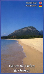
Sardinia’s eastern coast around the town of Orosei on a detailed, contoured, GPS compatible map at 1:35,000 from Abies Edizioni, with on the reverse notes on the area’s history, heritage and beaches. Contours are at 20m intervals with colouring for different types of vegetation. The map shows local footpaths and hiking trails, as well as recommended mountain bike routes. Symbols highlight various places of interest including campsites, beaches, diving and surfing sites, viewpoints, climbing sites, nuraghi, churches, etc. The map has a 1-km UTM grid. On the reverse are multilingual notes about the area and its heritage. Map legend and the notes include English.

Related Products:
 Baunei
 Gulf of Orosei
 Isola di San Pietro
Siniscola
Isola di San Pietro
Siniscola
 Urzulei
Posada
Loiri – Porto San Paolo
Villasimius – Torre delle Stelle – Costa Rei
Italy: Ed. Abies Recreational Maps of the Sardinian Coast
Gulf of Oristano
Santa Margherita to Calasetta
Bay of Porto Conte to Platamona
Capo San Lorenzo to Capitana
Urzulei
Posada
Loiri – Porto San Paolo
Villasimius – Torre delle Stelle – Costa Rei
Italy: Ed. Abies Recreational Maps of the Sardinian Coast
Gulf of Oristano
Santa Margherita to Calasetta
Bay of Porto Conte to Platamona
Capo San Lorenzo to Capitana
 Porto Rotondo to Capo Comino
 Santa Maria Navarrese to Quirra
Cagliari and Golfo degli Angeli
Marina di Sorso to Costa Paradiso
Santa Caterina di Pittinuri to Capo Caccia
Costa Smeralda: Portobello Di Gallura To Golfo Aranci
Santa Maria Navarrese to Quirra
Cagliari and Golfo degli Angeli
Marina di Sorso to Costa Paradiso
Santa Caterina di Pittinuri to Capo Caccia
Costa Smeralda: Portobello Di Gallura To Golfo Aranci
 Sardinia South-West: The Mining Coast Hiking Trail Guide
 North Sardinia Climbing Map
 Costa Rica Borch
 Malta – Gozo Kompass 235
 Mallorca East Reise Know-How
 Aeolian (Lipari) Islands Global Map Tourist Map
 Mallorca South Reise Know-How
 Mallorca North Reise Know-How
 Mallorca West Reise Know-How
 Saba (Dutch Antilles)
 Madagascar Reise Know-How
 Belize Dive Map
 Virgin Islands (US and British) ITMB
 Cuba ITMB
 O`ahu Island and Honolulu
 Curaรงao
 Elba Global Map Tourist Map
Spain: Reise Know-How Walking and Touring Maps of Mallorca
Elba Global Map Tourist Map
Spain: Reise Know-How Walking and Touring Maps of Mallorca
 Costa Smeralda Global Map Tourist Map
Costa Rica Reise Know-How
Costa Smeralda Global Map Tourist Map
Costa Rica Reise Know-How