Disclosure : This site contains affiliate links to products. We may receive a commission for purchases made through these links.
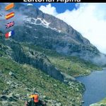
Ordesa and Monte Perdido National Park Editorial Alpina
Ordesa and Monte Perdido National Park at 1:40,000 on a GPS compatible recreational map in an extensive and very popular series from Editorial Alpina, including a booklet with English language descriptions of several walks, climbs, etc.Contours are at 20m intervals, with relief shading and altitude colouring. An overprint highlights waymarked PR hiking paths, the GR11, HRP and other long-distance routes, plus other footpaths and mountain trails. Symbols indicate climbing and potholing sites, alpine and cross-country skiing areas, various types of accommodation (hotels, youth hostels, campsites, refuges, mountain huts), information centres, places of interest, locations of petrol stations in the local villages and on access roads, etc. The map has a UTM grid and 1’ margin ticks. Map legend includes English. The accompanying booklet includes English language descriptions of 15 walks, 9 more strenuous ascents, 5 ski mountaineering trails, a list of shelters and youth hostels, plus general information about the area.PLEASE NOTE: – The same area is also covered by the Editorial Alpina’s set of two maps at 1:25,000 but without a booklet.- To see the full list of all the titles is this series, covering the Pyrenees and other areas of Spain, please click on the series link.

Related Products:
 Ordesa and Monte Perdido National Park 2-Map Set Editorial Alpina
 Ordesa – Monte Perdido National Park Editorial Alpina 2-Map Set
 Macizo de Monte Perdido – Valle de Ordesa – Pineta Editorial Alpina
 Cap de Creus Park Natural Editorial Alpina
Aigรผestortes and Estany de Sant Maurici National Park 2-Map Set Editorial Alpina
Cap de Creus Park Natural Editorial Alpina
Aigรผestortes and Estany de Sant Maurici National Park 2-Map Set Editorial Alpina
 La Alta Ruta de los Perdidos – Monte Perdido – Vignemale Editorial Alpina Hiking Circuit Map
 Cabo de Gata-Nรญjar Natural Park Editorial Alpina
 Posets-Maladeta Natural Park 2-Map Set Editorial Alpina
 Alt Pirineu Natural Park Editorial Alpina
 Cotiella ‘“ Peรฑa Montaรฑesa Editorial Alpina
 Sierra Nevada – La Alpujarra Editorial Alpina
 Picos de Europa National Park 2-Map Set Editorial Alpina
 Cavalls del Vent – Cadi-Moixero Natural Park Hiking Circuit Editorial Alpina
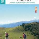
Bachimala – Valles de Chistau y Bielsa Editorial Alpina
Cavalls del Vent – Cadi-Moixero Natural Park Hiking Circuit Editorial Alpina
Bachimala – Valles de Chistau y Bielsa Editorial Alpina
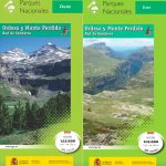 Ordesa and Monte Perdido National Park 2-Map Set
 Moixerรณ – La Tosa – Cadรญ-Moixerรณ Natural Park Editorial Alpina
Valles de Ansรณ & Echo Editorial Alpina
Moixerรณ – La Tosa – Cadรญ-Moixerรณ Natural Park Editorial Alpina
Valles de Ansรณ & Echo Editorial Alpina
 Valles de Belagua y Roncal Editorial Alpina
Garraf – la Morella – Eramprunya Editorial Alpina
Montserrat Nature Park Editorial Alpina
Valles de Belagua y Roncal Editorial Alpina
Garraf – la Morella – Eramprunya Editorial Alpina
Montserrat Nature Park Editorial Alpina
 Delta of the Ebro ‘“ Serra de Montsiร Editorial Alpina
 Garrotxa – Zona Volcanica Editorial Alpina
 Vall Fosca – Montsent de Pallars Editorial Alpina 2-Map Set
 Aneto – Maladeta – PN Posets Editorial Alpina
 Catllarร s – Picancel Editorial Alpina
 Ripollรจs Editorial Alpina
 Montgrony – Fonts del Llogregat – Parc Natural del Cadรญ-Moixerรฒ Editorial Alpina
 Mallorca – Tramuntana South Editorial Alpina
 Mallorca – Tramuntana North Editorial Alpina
 Mallorca – Tramuntana Central Editorial Alpina
 Muntanya d’Alinyร Editorial Alpina
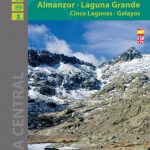 Sierra de Gredos – Almanzor – Laguna Grande Editorial Alpina
Montseny NP – Turo de l`Home – Les Agudas – Matagalls – la Calma Editorial Alpina 2-Map Set
Cingles de Berti – Sant Miquel des Fai Editorial Alpina
Montseny Editorial Alpina
Puigsacalm – Bellmunt Editorial Alpina
Sierra de Gredos – Almanzor – Laguna Grande Editorial Alpina
Montseny NP – Turo de l`Home – Les Agudas – Matagalls – la Calma Editorial Alpina 2-Map Set
Cingles de Berti – Sant Miquel des Fai Editorial Alpina
Montseny Editorial Alpina
Puigsacalm – Bellmunt Editorial Alpina
 Sierra de Huetor Natural Park Editorial Penibetica SPANISH
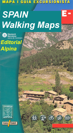
Spain: Editorial Alpina Walking Maps
Montnegre – Corredor Editorial Alpina
Sierra de Huetor Natural Park Editorial Penibetica SPANISH
Spain: Editorial Alpina Walking Maps
Montnegre – Corredor Editorial Alpina
 Menorca – Camรญ de Cavalls – GR223 Editorial Alpina CATALAN