Disclosure : This site contains affiliate links to products. We may receive a commission for purchases made through these links.
Ruta dels Estanys Amagats
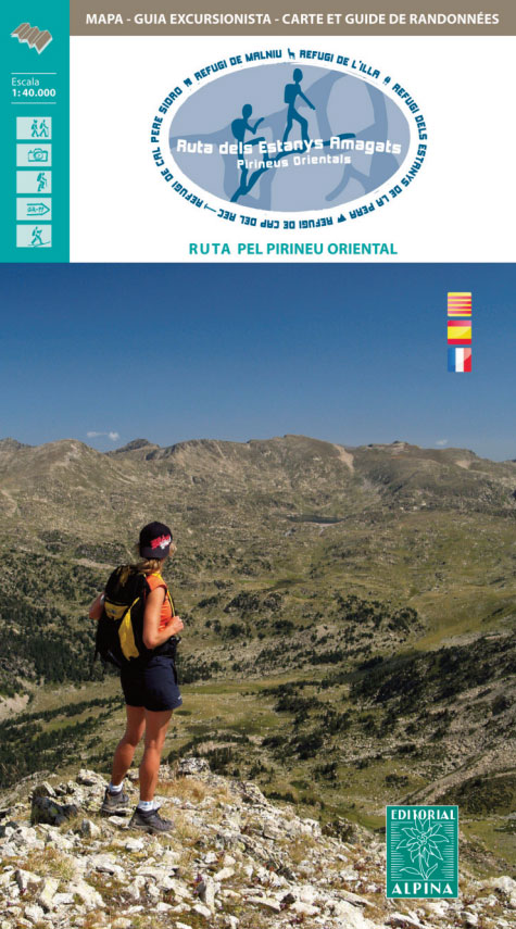
The Hidden Lakes (Ruta dels Estanys Amagats) Hiking Circuit, a 97km route across the Cerdanya region of the Spanish Pyrenees and Andorra, presented at 1:40,000 on a contoured and GPS compatible map from Editorial Alpina, with contact details of mountain refuges.The map has contours at 20m intervals, enhanced by relief shading. The Hidden Lakes circuit is prominently highlighted, with symbols indicating mountain refuges, campsites and other accommodation, both along the route itself and in the local villages. Also marked are various other facilities and places of interest including climbing and caving sites, car parks and locations of petrol stations, etc. The map has a UTM grid. Map legend includes English. Accompanying booklet with the route description is in Spanish and Catalan only.To see the list of all the maps from Editorial Alpina covering long-distance hiking routes please click on the series link.

Related Products:
 The Hidden Lakes (Ruta dels Estanys Amagats) Hiking Circuit
 La Alta Ruta de los Perdidos – Monte Perdido – Vignemale Editorial Alpina Hiking Circuit Map
 The Hermitage (Ruta de l`Ermitร ) Hiking Circuit
 Cavalls del Vent – Cadi-Moixero Natural Park Hiking Circuit Editorial Alpina
 La Ruta del Caracremada Editorial Piolet
Carros de Foc Hiking Circuit Editorial Alpina
La Ruta del Caracremada Editorial Piolet
Carros de Foc Hiking Circuit Editorial Alpina
 La Senda de Camille Editorial Alpina
 Valle de Benasque Editorial Alpina
 Posets-Maladeta Natural Park 2-Map Set Editorial Alpina
 Andorra – Comapedrosa – Engorgs – Jucla – Pessons – Tristaina Editorial Alpina
 Cerdanya – Alta Cerdanya – Capcir – Andorra Editorial Alpina
 Serra del Cadรญ – Pedraforca Editorial Alpina
 Travessa 3 Refugis – Caranรงร – Ulldeter – Coma de Vaca Editorial Alpina
 Muntanyes de Llibertat Hiking Circuit
Vignemale – Valle de Bujaruelo Editorial Alpina
Muntanyes de Llibertat Hiking Circuit
Vignemale – Valle de Bujaruelo Editorial Alpina
 Serra de Tramuntana Editorial Alpina 4-Map Set
 Ibiza – Formentera Editorial Alpina
 Valles de Belagua y Roncal Editorial Alpina
 Val d`Aran by UTMB Editorial Alpina Trail running race Map
 Mallorca – Tramuntana Central Editorial Alpina
Val d`Aran – Mauberme – Montardo – Molieres Editorial Alpina
Ordesa – Monte Perdido National Park Editorial Alpina 2-Map Set
Mallorca – Tramuntana Central Editorial Alpina
Val d`Aran – Mauberme – Montardo – Molieres Editorial Alpina
Ordesa – Monte Perdido National Park Editorial Alpina 2-Map Set
 Sobrarbe Central – Ainsa – Boltana Editorial Alpina
 Pass`Aran Circuit: Couserans – Val d`Aran
 Caps del Nord – Mallorca Editorial Alpina 2-Map Set
 Mallorca – Tramuntana South Editorial Alpina
 Costabona – Alta Val de Ter Editorial Alpina
 Mallorca – Tramuntana North Editorial Alpina
 Ordesa and Monte Perdido National Park 2-Map Set Editorial Alpina
 Valles de Irati y Aezkoa Editorial Alpina
 Macizo de Monte Perdido – Valle de Ordesa – Pineta Editorial Alpina
Valles de Ansรณ & Echo Editorial Alpina
Macizo de Monte Perdido – Valle de Ordesa – Pineta Editorial Alpina
Valles de Ansรณ & Echo Editorial Alpina
 Valle de Tena – Panticosa – Partacua – Sallent Editorial Alpina
 Vall de Lord – Port del Comte Editorial Alpina
 Mallorca North Walking & Cycling Map & Guide Editorial Alpina
Cingles de Berti – Sant Miquel des Fai Editorial Alpina
Mallorca North Walking & Cycling Map & Guide Editorial Alpina
Cingles de Berti – Sant Miquel des Fai Editorial Alpina
 Catllarร s – Picancel Editorial Alpina
 Sierra de Gredos – Almanzor – Laguna Grande Editorial Alpina
 Tour of the Canigรณ Hiking Circuit
Bachimala – Valles de Chistau y Bielsa Editorial Alpina
Tour of the Canigรณ Hiking Circuit
Bachimala – Valles de Chistau y Bielsa Editorial Alpina