Disclosure : This site contains affiliate links to products. We may receive a commission for purchases made through these links.
Mallorca – Tramuntana North Editorial Alpina
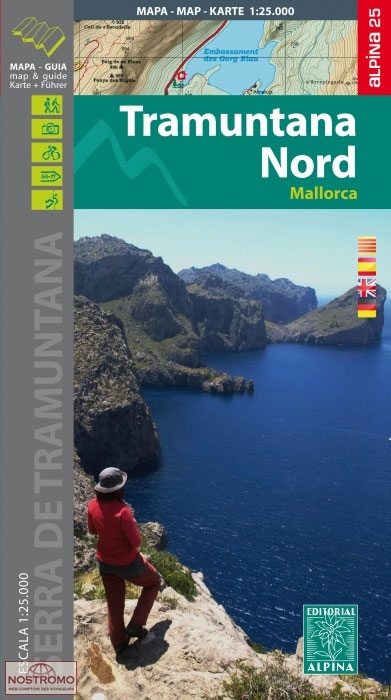
The northern part of Mallorca’s Serra de Tramuntana mountains on a contoured and GPS-compatible map at 1:25,000 from Editorial Alpina, highlighting numerous local hiking trails and the course of the GR221 long-distance trail, climbing and canyoning sites, refuges and campsites, etc. Accompanying booklet includes English-language descriptions of several recommended routes.The map has contours at 10m intervals, relief shading and numerous spot heights, plus colouring to show different types of vegetation. An overprint highlights walking trails, indicating routes which are not waymarked and/or steep and difficult to follow. Several trails are cross-referenced to their descriptions in the accompanying booklet. Symbols indicate mountain refuges, campsites and other accommodation, climbing and canyoning sites, etc. Road network shows car parks, petrol stations and local bus stops. The map has a 1-km UTM grid plus latitude and longitude margin ticks at 1’ intervals. Map legend includes English.An enlargement shows the Sanctuari de Lluc area in greater detail at 1:10,000. The booklet, with 30 pages in English, also provides contact details for mountain refuges and other useful information sources.To see other titles in Editorial Alpina’s extensive series of walking maps of Spain, including more titles covering Mallorca, please click on the series link.

Related Products:
 Mallorca – Tramuntana South Editorial Alpina
 Mallorca – Tramuntana Central Editorial Alpina
 Serra de Tramuntana Editorial Alpina 4-Map Set
 Mallorca North Walking & Cycling Map & Guide Editorial Alpina
 Sierra Nevada – La Alpujarra Editorial Alpina
 El Turbรณn ‘“ Alto Valle de Isรกbena Editorial Alpina
Bachimala – Valles de Chistau y Bielsa Editorial Alpina
El Turbรณn ‘“ Alto Valle de Isรกbena Editorial Alpina
Bachimala – Valles de Chistau y Bielsa Editorial Alpina
 Muntanya d’Alinyร Editorial Alpina
 Ripollรจs Editorial Alpina
 Valles de Ansรณ & Echo Editorial Alpina
 Valles de Belagua y Roncal Editorial Alpina
 Montseny Editorial Alpina
Valle de Tena – Panticosa – Partacua – Sallent Editorial Alpina
Montseny Editorial Alpina
Valle de Tena – Panticosa – Partacua – Sallent Editorial Alpina
 Cabo de Gata-Nรญjar Natural Park Editorial Alpina
 Vall de Lord – Port del Comte Editorial Alpina
 Caps del Nord – Mallorca Editorial Alpina 2-Map Set
Vall de Barravรฉs – Ribagorรงa Editorial Alpina
Caps del Nord – Mallorca Editorial Alpina 2-Map Set
Vall de Barravรฉs – Ribagorรงa Editorial Alpina
 Montseny NP – Turo de l`Home – Les Agudas – Matagalls – la Calma Editorial Alpina 2-Map Set
 Serralada de Marina Editorial Alpina
 Sรณller – Mallorca Editorial Alpina Map & Guide ENGLISH
 Mallorca – 60 Easy Hikes Editorial Alpina GR211-GR222 ENGLISH/GERMAN
Val d`Aran – Mauberme – Montardo – Molieres Editorial Alpina
Mallorca – 60 Easy Hikes Editorial Alpina GR211-GR222 ENGLISH/GERMAN
Val d`Aran – Mauberme – Montardo – Molieres Editorial Alpina
 Catllarร s – Picancel Editorial Alpina
 Serra del Cadรญ – Pedraforca Editorial Alpina
 Sierra de Gredos – Almanzor – Laguna Grande Editorial Alpina
 Congost de Mont-rebei Editorial Alpina
Garraf – la Morella – Eramprunya Editorial Alpina
Val d`Aran by UTMB Editorial Alpina Trail running race Map
Congost de Mont-rebei Editorial Alpina
Garraf – la Morella – Eramprunya Editorial Alpina
Val d`Aran by UTMB Editorial Alpina Trail running race Map
 Valle de Benasque Editorial Alpina
 La Senda de Camille Editorial Alpina
Puigsacalm – Bellmunt Editorial Alpina
La Senda de Camille Editorial Alpina
Puigsacalm – Bellmunt Editorial Alpina
 Montgrony – Fonts del Llogregat – Parc Natural del Cadรญ-Moixerรฒ Editorial Alpina
 Mallorca Central Plain – East and South Coasts Editorial Alpina
 Ibiza – Formentera Editorial Alpina
Cotiella ‘“ Peรฑa Montaรฑesa Editorial Alpina
Ibiza – Formentera Editorial Alpina
Cotiella ‘“ Peรฑa Montaรฑesa Editorial Alpina
 Delta of the Ebro ‘“ Serra de Montsiร Editorial Alpina
 Garrotxa – Zona Volcanica Editorial Alpina
Cingles de Berti – Sant Miquel des Fai Editorial Alpina
Sant Llorenc del Munt i l`Obac Editorial Alpina
Garrotxa – Zona Volcanica Editorial Alpina
Cingles de Berti – Sant Miquel des Fai Editorial Alpina
Sant Llorenc del Munt i l`Obac Editorial Alpina