Disclosure : This site contains affiliate links to products. We may receive a commission for purchases made through these links.
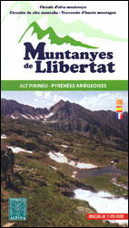
Muntanyes de Llibertat Hiking Circuit

Muntanyes de Llibertat Hiking Circuit, a 62km-long cross-border hiking trail in the central Pyrenees covering the routes of Republican refuges from Spain into France after the Civil War and of Jewish refuges from France during World War II, presented by Editorial Alpina at 1:25,000 on a contoured and GPS compatible map. Staring from the campsite in Graus near Tavascan on the Spanish side, the route crosses over to Aulus-les-Bains in France before returning to Spain where an alternative 2-day ‘Jewish Exodus” variant is also marked on the map.The map has contours at 10m intervals, enhanced by relief shading and numerous spot heights, plus colouring for forested areas. The course of the Muntanyes de Llibertat route is prominently highlighted. Symbols show various tourist facilities and places of interest, including different types of accommodation options (hotels, farms, refuges, campsites, youth hostels, etc), sport and recreational sites, etc. The map has a 1km UTM grid. Map legend includes English.Accompanying booklet provides a stage-by-stage description of the circuit and the variant, plus historical notes. The text is in French, Spanish and Catalan.To see the list of all the maps from Editorial Alpina covering long-distance hiking routes please click on the series link.


