Disclosure : This site contains affiliate links to products. We may receive a commission for purchases made through these links.
Chinchilla de Monte Aragon CNIG Topo 791

Related Products:
 Alhama de Aragon CNIG Topo 436
Molina de Aragon CNIG Topo 489
Monte Perdido CNIG Topo 146
Alhama de Aragon CNIG Topo 436
Molina de Aragon CNIG Topo 489
Monte Perdido CNIG Topo 146
 Tabuyo del Monte CNIG Topo 230-2
Monte Lope-Alvarez CNIG Topographic Map 946-III
Tabuyo del Monte CNIG Topo 230-2
Monte Lope-Alvarez CNIG Topographic Map 946-III
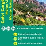 Calvi – Cargese – Monte Cinto – Monte Rotondo IGN 75029
 Monte Giuoco del Pallone – Monte Penna Monti Editore 09
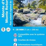 Monte d`Oro – Monte Rotondo – PNR de Corse IGN WATERPROOF 4251OTR
 Monte Stivo – Monte Bondone – Rovereto Kompass 687
 Monte d`Oro – Monte Rotondo – PNR de Corse IGN 4251OT
 Monte Fumaiolo – Monte Comero 18
 Alta Valle del Metauro: Valle del Candigliano, Monte Nerone, Monte Catria
 Aragon – Catalonia Michelin Regional 574
 Pyrenees – Costa Brava – Basque Country – Navarra – Aragon – Andorra – Catalonia
 Catherine of Aragon
 Katherine of Aragon, the True Queen
Foz CNIG Topo 9
Katherine of Aragon, the True Queen
Foz CNIG Topo 9
 Ibi CNIG Topo 846
Coy CNIG Topo 932
Tui CNIG Topo 260/261
Vic CNIG Topo 332
Roa CNIG Topo 345
Used CNIG Topo 464
Meira CNIG Topo 48
Bielsa CNIG Topo 179
Villabragima CNIG Topo 342
Cardenosa CNIG Topo 506
Alhambra CNIG Topo 787
Lerma CNIG Topo 276
Cistierna CNIG Topo 131
Sueca CNIG Topo 747
Ibi CNIG Topo 846
Coy CNIG Topo 932
Tui CNIG Topo 260/261
Vic CNIG Topo 332
Roa CNIG Topo 345
Used CNIG Topo 464
Meira CNIG Topo 48
Bielsa CNIG Topo 179
Villabragima CNIG Topo 342
Cardenosa CNIG Topo 506
Alhambra CNIG Topo 787
Lerma CNIG Topo 276
Cistierna CNIG Topo 131
Sueca CNIG Topo 747
 Elche / Elx CNIG Topo 893-894
Alcantara CNIG Topo 648
Cieza CNIG Topo 891-3
Elche / Elx CNIG Topo 893-894
Alcantara CNIG Topo 648
Cieza CNIG Topo 891-3
 Ocana CNIG Topo 631
Maguilla CNIG Topo 856
Pozoblanco CNIG Topo 859
Ocana CNIG Topo 631
Maguilla CNIG Topo 856
Pozoblanco CNIG Topo 859
 La Velles CNIG Topo 452
Mira CNIG Topo 665
Benalua CNIG Topo 993
La Velles CNIG Topo 452
Mira CNIG Topo 665
Benalua CNIG Topo 993