Disclosure : This site contains affiliate links to products. We may receive a commission for purchases made through these links.
Bialowieza Forest and Environs ENGLISH
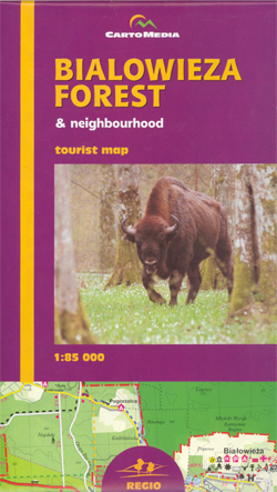
Bialowieza Forest (Puszcza Bialowieska – Bialowieza N.P.) and its environs on a detailed recreational map from Atikart, with street plans of Hajnรณwka and Bialowieza, plus English text covering most of the reverse side of the map describing towns and villages, etc.The map covers an area from Bielsk Podlaski to the border and presents a very detailed picture of the road network, places of interest and recreational facilities. Overprint highlights hiking trails indicating their waymarking; cycling, horse riding and canoeing trails are also marked. Symbols indicate numerous places of interest including observation towers, museums, places of worships and cemeteries of various denominations, cycle and canoe hire, various types of accommodation, etc.Road network shows locations of petrol stations and roads open to cars within the Bialowieza Forest boundary. Topography is shown by contours at 20m intervals with colouring for different type of land use. The map has no geographical coordinates.Map legend is in English and Polish, but extensive text on the reverse side is all in English and includes lists of tourist offices, accommodation and campsites.Also provided are street plans of Hajnรณwka and the Bialowieza village, both annotated with various facilities and services. *PLEASE NOTE:*The publishers of this map, Bialystok based Atikart, are part of CartoMedia – a distribution consortium of various Polish regional cartographic publishers. All the titles are available both under the imprint of their original publishers plus, with different ISBNs but retaining the same cartography and other features, with CartoMedia covers. In order to ensure the best possible service we will supply the latest edition under either imprint.

Related Products:
 Bialowieza Forest (Polish part)
 Bialowieska Forest – Bialowieza National Park ExpressMap Tourist Map
 Biebrza National Park ENGLISH
 Bialowieza / Puszcza Bialowieska National Park
 Western Tatras – Polish and Slovak
 Black Forest: Central and Northern Black Forest Cycle Tour (260km) Bikeline Map/Guide
 Poland: CartoMedia Walking Maps of Southern Polish Highlands
 Black Forest Rivers Cycling Routes Bikeline Map-Guide
 Bavarian Forest Central Kompass 196
 Bavarian Forest 3-Map Set Kompass 198
Beskid Maly
Bavarian Forest 3-Map Set Kompass 198
Beskid Maly
 Beskid Zywiecki
 Southern Black Forest Cycle Tour (240km) Bikeline Map/Guide
 Vilnius and Environs
Aukลกtadvaris and Environs
Kaunas and Environs West
Kaunas and Environs East
Southern Teutoburg Forest – Eggegebirge – Oberwรคlder Land Kompass 844
Lake Asveja and Environs
Vilnius and Environs
Aukลกtadvaris and Environs
Kaunas and Environs West
Kaunas and Environs East
Southern Teutoburg Forest – Eggegebirge – Oberwรคlder Land Kompass 844
Lake Asveja and Environs
 Tuchola Forest
 Black Forest F&B Top 10 Tips
Vilnius North West and Its Environs
Black Forest F&B Top 10 Tips
Vilnius North West and Its Environs
 Oglala National Grassland, Nebraska National Forest and Samuel R. McKelvie National Forest
Vilnius North East and Its Environs
Vilnius South West and Its Environs
Vilnius South East and Its Environs
Oglala National Grassland, Nebraska National Forest and Samuel R. McKelvie National Forest
Vilnius North East and Its Environs
Vilnius South West and Its Environs
Vilnius South East and Its Environs
 Thuringian Forest – Spessart – Lower Franconia F&B Road and Leisure Map
 Ottawa National Forest MI
 Forest of Bowland
 Moselle Cycle Route: Metz to the Rhine (310km) Bikeline Map/Guide ENGLISH Ed.
 Berlin and Environs Cycle Region Bikeline Map-Guide
 Upper Palatine Forest North Kompass 192
Palatinate – Palatinate Forest NP 2-Map Set Kompass 826
Upper Palatine Forest North Kompass 192
Palatinate – Palatinate Forest NP 2-Map Set Kompass 826
 Black Forest South Mountain Bike Guide
Szczecin and Environs
Black Forest South Mountain Bike Guide
Szczecin and Environs
 Elbe Cycle Trail Part 1: Prague – Magdeburg (500km) Bikeline Map/Guide ENGLISH Ed.
 Bavarian Forest Northern Kompass 195
 Danube Cycle Route Part 2: Passau to Vienna ENGLISH Ed.
 Baden-Wรผrttemberg – Black Forest K+F Regional Map
 Black Forest – Swabian Alb – Lake Constance F&B Road and Leisure Map