Disclosure : This site contains affiliate links to products. We may receive a commission for purchases made through these links.
Messinia Geopsis
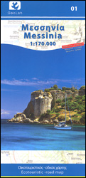
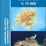
Greek province on Messina on the Peloponnese on a detailed, GPS compatible, waterproof and tear-resistant road map 1:170,000 from Geopsis with a particularly vivid presentation of the Taygetos Mountains. All place names are in both Greek and Latin alphabet; locations of historical or natural interest are prominently highlighted.Coverage extends to include Tripoli in the north-eastern corner of the map. Bold relief shading provides an almost 3-D picture of the Taygetos range, with many spot heights. The map also shows the region’s protected hunting areas. Road classification indicates local dirt roads and shows locations of petrol stations. Symbols highlight various places of interest including campsites, beaches, various sport and recreational locations and facilities, etc. The map has a 10-km UTM grid plus crosshairs for latitude and longitude at 10’. Map legend includes English. On the reverse are bilingual Greek and English notes about the province, including its castles and archaeological sites, museums, beaches and natural sites.

Related Products:
 Taygetos – North Taygetos Anavasi 8.1
 Messinia Anavasi 17
 Lesbos Geopsis 211
 Kos Geopsis 212
 Thasos Geopsis 214
 Olympus Geopsis 139
 Pirin (BG) – Orvilos – Vrontou (GR) Geopsis 134
 Chalkidiki / Halkidiki – Thessaloniki Street Plan Terrain Editions 412
 Attica – Boeotia Anavasi 10
 Eastern Rhodopes / Rodopi Geopsis 131
 Evia / Euboea Terrain Editions
 Evia / Euboea – Skyros Anavasi 04
 Mykonos – Delos – Rheneia / Rineia Anavasi 10.42
 Peloponnese Anavasi Road Atlas
 Central Rhodopes / Rodopi Geopsis 132
 Corfu Orama Editions 302
 Greece: Attika and Central Greece Road Atlas
 Western Rhodopes / Rodopi – Falakro Geopsis 133
 Greece Anavasi Road Map
 Santorini – Thirasia Anavasi 10.24
 Rhodes & Symi Anavasi 10.38
 Egina / Aegina Orama Editions 338
 Kythnos Anavasi 10.44
 Lesbos: Mitilini Peninsula 18K Geopsis Map
 Barcelona Province
 Iraklion – Rethymnon – Central Crete Anavasi 93
 Eastern Crete Terrain Editions 450
 Central Crete Terrain Editions 449
 Western Crete Terrain Editions 448
 Mount Pelion – Mount Mavrovouni Anavasi 4.3/4.4
 Macedonia Anavasi Regional Map R4
 Greece F&B
 Sifnos Anavasi 10.26
 Lousios Anavasi 8.51
 Lesbos: Aghiasos & Environs 18K Geopsis Map
 Crere: Heraklion Prefecture 150K Terrain Editions Map
 Astypalea / Astypalaia Orama Editions 322
 Alonisos – Northern Sporades Marine Park Anavasi 9.2
 Serifos Anavasi 10.25
 Chania – Gavdos Anavasi 94