Disclosure : This site contains affiliate links to products. We may receive a commission for purchases made through these links.
Stanford`s New Library Chart of the World (1920) – A2 Wall Map, Paper – Print on Demand
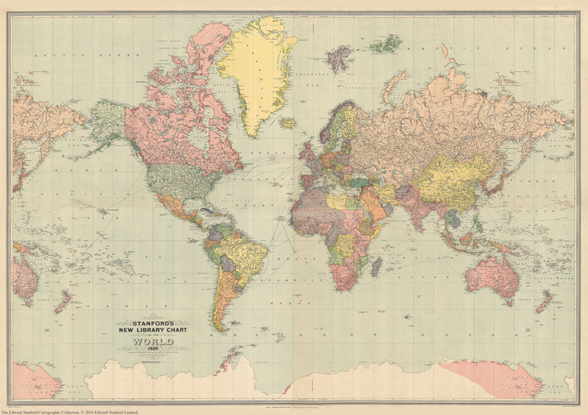
Print on Demand map from the Edward Stanford Cartographic Collection archive.The Stanford’s New Library Chart of the World is from a fascinating series of reproductions from our Edward Stanford Cartographic Collection archive. This map was published by Stanfords in January 1920 and says ‘drawn to an equatorial scale of 350 nautical miles to 1 inch.Displays submarine telegraph cables.Published just after World War I the boundaries are as per the Treaty of Versailles. The British Empire, at its height, is shown in dark pink.This is a very interesting map for anyone with an interest in history as it shows the world as it was in the 1920s from a British cartographer’s viewpoint.This is for the A2 paper version.

Related Products:
 Stanford`s New Library Chart of the World (1920) – A3 Wall Map, Paper – Print on Demand
Stanford`s New Library Chart of the World (1920) – Original Size Wall Map, Paper – Print on Demand
Stanford`s New Library Chart of the World (1920) – A3 Wall Map, Paper – Print on Demand
Stanford`s New Library Chart of the World (1920) – Original Size Wall Map, Paper – Print on Demand
 Stanford`s New Library Chart of the World (1920) – Original Size Wall Map, Canvas – Print on Demand
Stanford`s New Library Chart of the World (1920) – A1 Wall Map, Paper
Stanford`s New Library Chart of the World (1920) – A3 Wall Map, Canvas
Stanford`s New Library Chart of the World (1920) – A2 Wall Map, Canvas
Stanford`s New Library Chart of the World (1920) – A1 Wall Map, Canvas
Stanford`s New Library Chart of the World (1920) – Original Size Wall Map, Canvas – Print on Demand
Stanford`s New Library Chart of the World (1920) – A1 Wall Map, Paper
Stanford`s New Library Chart of the World (1920) – A3 Wall Map, Canvas
Stanford`s New Library Chart of the World (1920) – A2 Wall Map, Canvas
Stanford`s New Library Chart of the World (1920) – A1 Wall Map, Canvas
 Stanford`s General Map of the World (1920) – A1 Wall Map, Paper – Print on Demand
 Stanford`s Library Map of Japan (1879) – A1 Wall Map, Paper – Print on Demand
 Stanford`s Varty`s Roman Empire Map (1879) – A4 Wall Map, Paper – Print on Demand
Stanford`s Varty`s Roman Empire Map (1879) – A1 Wall Map, Paper – Print on Demand
Stanford`s Varty`s Roman Empire Map (1879) – A4 Wall Map, Paper – Print on Demand
Stanford`s Varty`s Roman Empire Map (1879) – A1 Wall Map, Paper – Print on Demand
 Stanford`s Library Map of London and its Suburbs (1878) – A1 Wall Map, Paper – Print on Demand
 Stanford`s Map of the British Metropolis: London (1877) – A1 Wall Map, Paper – Print on Demand
 Stanford`s Library Map of the World (1879) – A2 Wall Map, Paper – Print on Demand
Stanford`s Library Map of the World (1879) – A1 Wall Map, Paper – Print on Demand
Stanford`s Library Map of the World (1879) – A2 Wall Map, Paper – Print on Demand
Stanford`s Library Map of the World (1879) – A1 Wall Map, Paper – Print on Demand
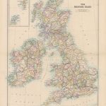
 Stanford`s Folio British Isles Map (1884) – A2 Wall Map, Paper – Print on Demand
 Stanford`s South Polar Chart (1901) – A1 Wall Map, Paper – Print on Demand
 Stanford`s Library Map of South America (1864) – A2 Wall Map, Canvas – Print on Demand
 Stanford`s Folio British Isles Map (1884) – A1 Wall Map, Paper – Special Edition – Print on Demand
 Stanford`s Library Map of London Sheet 10 Black and White (1862) – A3 Wall Map, Paper – Print on Demand
 Stanford`s New Map of Kabul (1880) – A1 Wall Map, Paper – Print on Demand
 Stanford`s Route Map of the Earth Colour (1854) – A1 Wall Map, Paper – Print on Demand
 Stanford`s Facsimile of the Hereford Mappa Mundi (1869) – A3 Wall Map, Paper – Print on Demand
Stanford`s Facsimile of the Hereford Mappa Mundi (1869) – A1 Wall Map, Paper – Print on Demand
Stanford`s Facsimile of the Hereford Mappa Mundi (1869) – A3 Wall Map, Paper – Print on Demand
Stanford`s Facsimile of the Hereford Mappa Mundi (1869) – A1 Wall Map, Paper – Print on Demand
 Stanford`s Folio Smaller Railway Map of the United States (1876) – A3 Wall Map, Paper – Print on Demand
 Stanford`s Chart of the Solent, Spithead and Southampton Water (1932) – A3 Wall Map, Paper – Print on Demand
Stanford`s Chart of the Solent, Spithead and Southampton Water (1932) – A2 Wall Map, Paper – Print on Demand
Stanford`s Chart of the Solent, Spithead and Southampton Water (1932) – A1 Wall Map, Paper – Print on Demand
Stanford`s Chart of the Solent, Spithead and Southampton Water (1932) – A3 Wall Map, Paper – Print on Demand
Stanford`s Chart of the Solent, Spithead and Southampton Water (1932) – A2 Wall Map, Paper – Print on Demand
Stanford`s Chart of the Solent, Spithead and Southampton Water (1932) – A1 Wall Map, Paper – Print on Demand
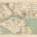
 Stanford`s Map of the Siberian Railway (1904) – A2 Wall Map, Paper – Print on Demand
Stanford`s Folio Smaller Railway Map of the United States (1876) – A2 Wall Map, Paper – Print on Demand
Stanford`s Map of the Siberian Railway (1904) – A3 Wall Map, Paper – Print on Demand
Stanford`s Map of the Siberian Railway (1904) – A1 Wall Map, Paper – Print on Demand
Stanford`s Map of the Siberian Railway (1904) – A2 Wall Map, Paper – Print on Demand
Stanford`s Folio Smaller Railway Map of the United States (1876) – A2 Wall Map, Paper – Print on Demand
Stanford`s Map of the Siberian Railway (1904) – A3 Wall Map, Paper – Print on Demand
Stanford`s Map of the Siberian Railway (1904) – A1 Wall Map, Paper – Print on Demand
 Stanford`s Pacific-centred World Map (1884) – A1 Wall Map, Canvas – Print on Demand
Stanford`s Chart of the Solent, Spithead and Southampton Water (1932) – Original Size Wall Map, Paper – Print on Demand
Stanford`s Pacific-centred World Map (1884) – A1 Wall Map, Canvas – Print on Demand
Stanford`s Chart of the Solent, Spithead and Southampton Water (1932) – Original Size Wall Map, Paper – Print on Demand
 Stanford`s New Two Inch Map of London (1913) – A2 Wall Map, Canvas – Print on Demand
Stanford`s Map of the Siberian Railway (1904) – Original Size Wall Map, Paper – Print on Demand
Stanford`s Chart of the Solent, Spithead and Southampton Water (1932) – A3 Wall Map, Canvas – Print on Demand
Stanford`s Folio Smaller Railway Map of the United States (1876) – A2 Wall Map, Canvas – Print on Demand
Stanford`s Map of the Siberian Railway (1904) – A1 Wall Map, Canvas – Print on Demand
Stanford`s New Two Inch Map of London (1913) – A2 Wall Map, Canvas – Print on Demand
Stanford`s Map of the Siberian Railway (1904) – Original Size Wall Map, Paper – Print on Demand
Stanford`s Chart of the Solent, Spithead and Southampton Water (1932) – A3 Wall Map, Canvas – Print on Demand
Stanford`s Folio Smaller Railway Map of the United States (1876) – A2 Wall Map, Canvas – Print on Demand
Stanford`s Map of the Siberian Railway (1904) – A1 Wall Map, Canvas – Print on Demand
 Stanford`s Map of the County of London (1888) – A1 Wall Map, Paper – Print on Demand