Disclosure : This site contains affiliate links to products. We may receive a commission for purchases made through these links.
Stanford`s Folio North America Map (1884) – A1 Wall Map, Paper
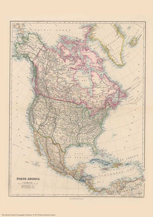
The Stanford’s Map of North America is from a fascinating series of reproductions from our Edward Stanford Cartographic Collection archive. This map was originally published in 1884.Originally published in 1884, this map features bright colours highlighting international borders, with corresponding colouring indicating state/provincial borders within USA, Canada and Mexico. Plain background with hachure for mountain ranges makes the place names marked on the map easy to read. Several mountain peaks, mainly in USA, are shown with heights (in feet). In common with other map published by Stanfords around that time, numerous smaller rivers are named. Latitude and longitude lines are drawn at 5ยฐ intervals. Whilst at the first glance there have been few significant changes in the international boundaries. Panama is still shown as part of Colombia plus Greenland and Iceland are in Danish colours, internal administrative border provide much interesting detail. In the US all the states which acceded to the Union after the map’s publication date are already there, but with the Dakotas as one state and Oklahoma shown as the Indian Territory and its panhandle as separate Public Lands. In Canada, the northern borders of most of the provinces are much further south than today, southern Saskatchewan called Assiniboia and northern Alberta as Athabasca, etc. Coverage of Canada extends north to the Parry Islands (now Queen Elizabeth Islands), with only the south-eastern coast of the Ellesmere Island. In the Caribbean individual islands are in the colours of their colonial powers (their names are not marked on the map). Another interesting feature are the markings for the submarine telegraph cables. This is the A1 paper version.

Related Products:
 Stanford`s Folio North America Map (1884) – A3 Wall Map, Paper
Stanford`s Folio North America Map (1884) – A2 Wall Map, Paper
Stanford`s Folio North America Map (1884) – A4 Wall Map, Canvas
Stanford`s Folio North America Map (1884) – A3 Wall Map, Canvas
Stanford`s Folio North America Map (1884) – A2 Wall Map, Canvas
Stanford`s Folio North America Map (1884) – A3 Wall Map, Paper
Stanford`s Folio North America Map (1884) – A2 Wall Map, Paper
Stanford`s Folio North America Map (1884) – A4 Wall Map, Canvas
Stanford`s Folio North America Map (1884) – A3 Wall Map, Canvas
Stanford`s Folio North America Map (1884) – A2 Wall Map, Canvas
 Stanford`s Folio British Isles Map (1884) – A4 Wall Map, Paper
Stanford`s Folio British Isles Map (1884) – A3 Wall Map, Paper
Stanford`s Folio British Isles Map (1884) – A1 Wall Map, Paper
Stanford`s Folio British Isles Map (1884) – A4 Wall Map, Paper
Stanford`s Folio British Isles Map (1884) – A3 Wall Map, Paper
Stanford`s Folio British Isles Map (1884) – A1 Wall Map, Paper
 Stanford`s Folio Europe Map, by J. Arrowsmith (1884) – A4 Wall Map, Paper
Stanford`s Folio Europe Map, by J. Arrowsmith (1884) – A3 Wall Map, Paper
Stanford`s Folio British Isles Map (1884) – A2 Wall Map, Paper – Print on Demand
Stanford`s Folio Europe Map, by J. Arrowsmith (1884) – A2 Wall Map, Paper
Stanford`s Folio Europe Map, by J. Arrowsmith (1884) – A1 Wall Map, Paper
Stanford`s Folio Europe Map, by J. Arrowsmith (1884) – A4 Wall Map, Paper
Stanford`s Folio Europe Map, by J. Arrowsmith (1884) – A3 Wall Map, Paper
Stanford`s Folio British Isles Map (1884) – A2 Wall Map, Paper – Print on Demand
Stanford`s Folio Europe Map, by J. Arrowsmith (1884) – A2 Wall Map, Paper
Stanford`s Folio Europe Map, by J. Arrowsmith (1884) – A1 Wall Map, Paper
 Stanford`s Folio Asia Map, by J. Arrowsmith (1884) – A3 Wall Map, Paper
Stanford`s Folio Asia Map, by J. Arrowsmith (1884) – A2 Wall Map, Paper
Stanford`s Folio Asia Map, by J. Arrowsmith (1884) – A1 Wall Map, Paper
Stanford`s Folio Asia Map, by J. Arrowsmith (1884) – A3 Wall Map, Paper
Stanford`s Folio Asia Map, by J. Arrowsmith (1884) – A2 Wall Map, Paper
Stanford`s Folio Asia Map, by J. Arrowsmith (1884) – A1 Wall Map, Paper
 Stanford`s Folio British Isles Map (1884) – A1 Wall Map, Paper – Special Edition – Print on Demand
Stanford`s Folio British Isles Map (1884) – A2 Wall Map, Canvas
Stanford`s Folio British Isles Map (1884) – A4 Wall Map, Canvas
Stanford`s Folio British Isles Map (1884) – A3 Wall Map, Canvas
Stanford`s Folio British Isles Map (1884) – A1 Wall Map, Canvas
Stanford`s Folio Europe Map, by J. Arrowsmith (1884) – A3 Wall Map, Canvas
Stanford`s Folio Europe Map, by J. Arrowsmith (1884) – A2 Wall Map, Canvas
Stanford`s Folio Europe Map, by J. Arrowsmith (1884) – A1 Wall Map, Canvas
Stanford`s Folio Europe Map, by J. Arrowsmith (1884) – A4 Wall Map, Canvas
Stanford`s Folio British Isles Map (1884) – A1 Wall Map, Paper – Special Edition – Print on Demand
Stanford`s Folio British Isles Map (1884) – A2 Wall Map, Canvas
Stanford`s Folio British Isles Map (1884) – A4 Wall Map, Canvas
Stanford`s Folio British Isles Map (1884) – A3 Wall Map, Canvas
Stanford`s Folio British Isles Map (1884) – A1 Wall Map, Canvas
Stanford`s Folio Europe Map, by J. Arrowsmith (1884) – A3 Wall Map, Canvas
Stanford`s Folio Europe Map, by J. Arrowsmith (1884) – A2 Wall Map, Canvas
Stanford`s Folio Europe Map, by J. Arrowsmith (1884) – A1 Wall Map, Canvas
Stanford`s Folio Europe Map, by J. Arrowsmith (1884) – A4 Wall Map, Canvas
 Stanford`s Folio British Isles Map (1884) – A1 Wall Map, Canvas – Special Edition
Stanford`s Folio Asia Map, by J. Arrowsmith (1884) – A4 Wall Map, Canvas
Stanford`s Folio Asia Map, by J. Arrowsmith (1884) – A3 Wall Map, Canvas
Stanford`s Folio Asia Map, by J. Arrowsmith (1884) – A2 Wall Map, Canvas
Stanford`s Folio Asia Map, by J. Arrowsmith (1884) – A1 Wall Map, Canvas
Stanford`s Folio British Isles Map (1884) – A1 Wall Map, Canvas – Special Edition
Stanford`s Folio Asia Map, by J. Arrowsmith (1884) – A4 Wall Map, Canvas
Stanford`s Folio Asia Map, by J. Arrowsmith (1884) – A3 Wall Map, Canvas
Stanford`s Folio Asia Map, by J. Arrowsmith (1884) – A2 Wall Map, Canvas
Stanford`s Folio Asia Map, by J. Arrowsmith (1884) – A1 Wall Map, Canvas
 Stanford`s Pacific-centred World Map (1884) – A3 Wall Map, Paper
Stanford`s Pacific-centred World Map (1884) – A2 Wall Map, Paper
Stanford`s Pacific-centred World Map (1884) – A1 Wall Map, Paper
Stanford`s Pacific-centred World Map (1884) – A3 Wall Map, Paper
Stanford`s Pacific-centred World Map (1884) – A2 Wall Map, Paper
Stanford`s Pacific-centred World Map (1884) – A1 Wall Map, Paper
 Stanford`s Folio Japan Map (1884) – A3 Wall Map, Paper
Stanford`s Folio Japan Map (1884) – A2 Wall Map, Paper
Stanford`s Folio Japan Map (1884) – A1 Wall Map, Paper
Stanford`s Folio Japan Map (1884) – A3 Wall Map, Paper
Stanford`s Folio Japan Map (1884) – A2 Wall Map, Paper
Stanford`s Folio Japan Map (1884) – A1 Wall Map, Paper
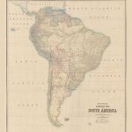 Stanford`s Library Map of South America (1864) – A3 Wall Map, Paper
Stanford`s Library Map of South America (1864) – A2 Wall Map, Paper
Stanford`s Library Map of South America (1864) – A1 Wall Map, Paper
Stanford`s Library Map of South America (1864) – A3 Wall Map, Paper
Stanford`s Library Map of South America (1864) – A2 Wall Map, Paper
Stanford`s Library Map of South America (1864) – A1 Wall Map, Paper