Disclosure : This site contains affiliate links to products. We may receive a commission for purchases made through these links.
Warsaw Marco Polo City Map
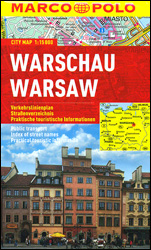
Warsaw at 1:15,000 on a pocket-size street plan from MairDumont printed on durable, waterproof and tear-resistant synthetic paper, with an enlargement presenting the city centre in greater detail, metro stations clearly marked and the whole network also presented on a separate diagram, tram and bus routes shown with stops and line numbers, lists of useful addresses, etc.Warsaw’s city centre is presented in greater detail on an enlargement at 1:10,000. Tram and bus routes are shown with stops and line numbers, and metro stations are clearly marked. For drivers the plan indicates one way streets and pedestrianized areas. Important buildings and places of interest are highlighted and annotated with their Polish names. Multilingual map legend includes English.The index is on the reverse side and includes lists of useful contact details for tourist information offices, hotel reservation, car hire, places of entertainment, emergency services, etc. The map also includes a diagram of the city’s metro network and a small road map of its environs.

Related Products:
 Budapest Marco Polo City Map
 Prague Marco Polo City Map
 Brussels Marco Polo City Map
 Berlin Marco Polo City Map
 Helsinki City Map
 Bangkok Marco Polo City Map
 Warsaw & Poland East ITMB
 Istanbul Marco Polo City Map
 St Petersburg Marco Polo City Map
 Hong Kong Marco Polo City Map
 Rio de Janeiro Marco Polo City Map
 Florence Marco Polo City Map
 Warsaw – Lomianki – Zabki ExpressMap Street Plan
 Cape Town Marco Polo City Map
 Boston Marco Polo City Map
 Warsaw F&B City Pocket Map
 Innsbruck City Map
 Helsinki & Southern Finland ITMB
 Frankfurt Marco Polo City Map
 Budapest City Plan
 Riga City Center Jana Seta Street Plan
Hamburg Marco Polo City Map
Riga City Center Jana Seta Street Plan
Hamburg Marco Polo City Map
 Munich Marco Polo City Map
 Tallinn Public Transport Map
 Helsinki City Map & Guide
 Austria – Liechtenstein – South Tyrol Marco Polo Road Atlas
 Istanbul & Northwest Turkey ITMB
 Stockholm Borch
 Riga ITMB
 Zurich & Switzerland NW ITMB
 Paris Marco Polo City Map
 Canada Marco Polo Map
 Gothenburg Tourist Map
 Brazil – Bolivia – Paraguay – Uruguay Marco Polo Map
 Hungary – Budapest Road Atlas SPIRAL-BOUND
 Insight Guides Explore Warsaw
 Prague Street Atlas
 Prague Pocket Atlas
 Prague Borch
 Los Angeles Marco Polo City Map