Disclosure : This site contains affiliate links to products. We may receive a commission for purchases made through these links.
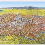
Lucerne – Central Switzerland Hallwag Panorama Map
Beautiful panorama drawing, with each valley and mountain clearly visible. Name and altitude are given for numerous peaks. The map also shows the railway network, with towns and villages. Excellent for planning or retracing journeys across this wonderful landscape.

Related Products:
 Switzerland Hallwag Panorama Map
Ticino Hallwag Panorama Map
Switzerland Hallwag Panorama Map
Ticino Hallwag Panorama Map
 Bernese Oberland Hallwag Panorama Map
 Valais / Wallis Hallwag Panorama Map
 Graubรผnden Hallwag Panorama Map
 Switzerland, My Holiday Map
 Alps in Summer Panorama Wall Map
 Switzerland Hallwag Touring Atlas
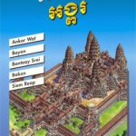 Angkor Gecko Panorama Map
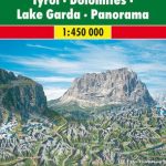
 South Tyrol – Dolomites Tabacco Road and Panorama Map
Switzerland Hallwag New Travel Map
South Tyrol – Dolomites Tabacco Road and Panorama Map
Switzerland Hallwag New Travel Map
 Dolomites ‘“ Lake Garda ‘“ Verona – Venice 200K Tabacco Road & Panorama Map
Tectonic Map of Switzerland
Dolomites ‘“ Lake Garda ‘“ Verona – Venice 200K Tabacco Road & Panorama Map
Tectonic Map of Switzerland
 Switzerland Hallwag City Atlas
Geological Map of Switzerland
Switzerland Hallwag City Atlas
Geological Map of Switzerland
 North Central – Great Plains USA 02 Hallwag Road Map
 South Central USA 07 Hallwag Road Map
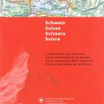 Switzerland 500K Swisstopo 0070
Lake Constance F&B Leisure & Panorama
Switzerland Hallwag Motorcycle Map Set
Switzerland 500K Swisstopo 0070
Lake Constance F&B Leisure & Panorama
Switzerland Hallwag Motorcycle Map Set
 Tyrol – Dolomites Road and Panorama F&B
 Switzerland Borch
 Austria Freytag & Berndt Panorama Wall Map
 Switzerland: Hallwag/K+F 33 Hiking Trails Maps
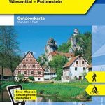
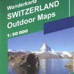 Switzerland: Hallwag 50K Outdoor Maps
 Switzerland: Hallwag 50K Mountain Biking Maps
 The British Museum: Panorama Pops
 Lake Lucerne – Engelberg – Lucerne – Schwyz K+F Hiking Map 11
 Ireland Hallwag Road Map
 Stonehenge: Panorama Pops
 Africa East & Central ITMB
 Florence: Panorama Pops
 Cordillera Cantabrica – Asturias and the Surrounding Provinces Adrados Map
 Lucerne Hallwag 3in1 City Map
 Scotland Panorama
 Zurich Panorama Plan
 Great Lakes USA 03 Hallwag Road Map
 Switzerland K+F Administrative Map