Disclosure : This site contains affiliate links to products. We may receive a commission for purchases made through these links.
Amsterdam F&B
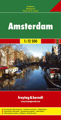
Amsterdam on a large street plan of Freytag & Berndt, covering the city within its motorway ringroad, but extending slightly further west to include the districts adjoining the metro ring and south to central Amstelveen and Amsterdam Zuid-Oost.Main traffic arteries are highlighted and motorway junctions and exits well presented. One way streets are marked throughout the city. Metro and railway stations and ferry routes on the IJ are clearly marked, and the city’s main places of interest and various institutions highlighted. There is no separate enlargement for the central area. Map legend includes English. Street index is in the reverse.

Related Products:
 Amsterdam Falkplan Street Plan and Cycling Map
 Amsterdam Falkplan Street Plan
 Amsterdam Michelin City Map
 Amsterdam Michelin Citymap
 St Petersburg Marco Polo City Map
 Amsterdam Citymap & More
 Amsterdam Borch
 Amsterdam Red Maps
Madrid Essential Telstar Map
Amsterdam Red Maps
Madrid Essential Telstar Map
 Prague F&B
 Rome
Rome
 St. Petersburg Jana Seta Street Plan
 Palma de Mallorca City Map / Mallorca Road Map
 Warsaw Marco Polo City Map
 Amsterdam PopOut
 Amsterdam Flexi Map
 Seville Central
 Netherlands
 Brussels Hike & Bike Map
 Stockholm Borch
 Greater Brussels Hike & Bike Map
 Halle Forest Hike & Bike Map
 Moscow Jana Seta Street Plan
 Barcelona “Maps to Go” Street Plan
 Amsterdam F&B City Pocket Map
 Milan Red Maps
 Valencia Michelin City Map
Palermo TCI Street Plan
Valencia Michelin City Map
Palermo TCI Street Plan
 Stockholm & Southern Sweden ITMB
 Oslo / Bergen & South of Norway ITMB
 Seville Michelin City Map
 Mumbai / Bombay – India West Coast ITMB
 Girona/Gerona Michelin City Map
 Porto Michelin City Plan and Index
 Budapest City Plan
 Tunis
Tunis
 Stockholm F&B
 Vancouver & Greater Vancouver ITMB
 Budapest Classic Plan
 Budapest Comfort Plan