Disclosure : This site contains affiliate links to products. We may receive a commission for purchases made through these links.
Valais / Wallis Swisstopo 105
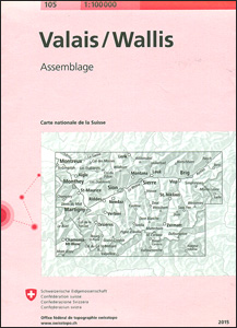
Swiss canton of Valais / Wallis on a Swiss topographic survey map at 1:100,000. Coverage extends from Chamonix and Mont Blanc eastwards to include many of the most popular destinations in the Swiss Alps: the Mattertal with Zermatt, Randa and St. Niklaus, Saas Fee, Verbier, Crans-Montana, the peaks of Matterhorn, Dom with the Michabel range, Monte Rosa, Simplon Pass, etc. Current 2015 edition of this title has the lines of the Swiss National Grid at 1km intervals.Maps in the Swiss topographic survey at 1:100,000 from Swisstopo are highly regarded for their superb use of graphic relief and hill shading, presenting an almost 3-D picture of the country`s mountainous terrain. Coverage is available either as small size standard sheets ‘“ Nos 26 to 48, each covering 70 x 48 km / 43 x 30 miles approx, or as larger size maps – Nos. 101 onwards, each covering 100 x 70 km / 62 x 43 miles approx.Both formats have identical cartography, with contours at 50-metres intervals. Standard sheets include margin ticks showing latitude and longitude in steps of 10`, and both formats have an overprint showing the Swiss national grid lines at 10km intervals; latest editions of the larger sheets now have the Swiss grid lines at 1km intervals. Standard sheets have a map legend in the language of the area covered by the map. The larger sheets have no legend but a separate ‘Conventional Signs” leaflet, in English, can be provided with the map.To see the list of titles in this series please click on the series link.


