Disclosure : This site contains affiliate links to products. We may receive a commission for purchases made through these links.
Mont-Blanc – Annecy Didier Richard 02
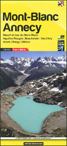
Mont Blanc Massif and the adjoining region of the French Alps at 1:60,000 on a contoured and GPS compatible map from Didier Richard with a base derived from IGN’s topographic survey, highlighting both local hiking routes and the GR network of long-distance paths, gรฎtes and mountain refuges, interesting natural and cultural sites, etc. The map covers the whole of Tour du Mont Blanc (TMB), indicating stopover facilities in its Italian and Swiss sections. Coverage includes Chamonix, les Houches, Argentiรจre, Sixt, Samoรซns, les Carroz, Flaine, Morillon, Cluses, le Grand-Bornand, le Chinaillon, Boneville, parts of Annecy and Lake Annecy, Salanches, St-Gervais-les-Bains, Megรจve, les Contamines-Montjoie, les Saises, Ugine, Albertville, la Rosiรจre, etc, as well as along the TMB in Italy Courmayeur and in Switzerland Champex.Relief is portrayed by contours at 50m intervals with additional hill shading and colouring for different types of vegetation. An overprint highlights local hiking trails, indicating difficult sections and routes which are part of the GR network. Bold symbols show gรฎtes accessible by car, mountain refuges accessible only on foot, via ferrata sites, mountain bike centres, interesting cultural or natural sites, etc. The map has a UTM grid. Map legend includes English. To see the list of all the titles in this series please click on the series link.PLEASE NOTE: the same cartography is also available as a double-sided mini map at 1:50,000 covering a much smaller area but including the whole of the Tour of Mont Blanc.

Related Products:
 Mont Blanc Pocket Map Edition Didier Richard
 Corsica North Didier Richard 08
 Corsica South Didier Richard 09
 Annecy – Albertville – Chamonix-Mont-Blanc – Massif du Mont Blanc IGN TOP100 144
 Vanoise National Park – Beaufortain Didier Richard 04
 รcrins Massif National Park Didier Richard 05
 Queyras – Ubaye Didier Richard
 Vercors Didier Richard
France: Didier Richard Hiking Maps of South Eastern France and Corsica
Vercors Didier Richard
France: Didier Richard Hiking Maps of South Eastern France and Corsica
 Monts d`Ardรจche Didier Richard
 Chamonix-Mont-Blanc – Massif du Mont-Blanc IGN WATERPROOF 3630OTR
 Tour du Mont Blanc Editions MPA Panoramic Map
 Chamonix-Mont-Blanc – Massif du Mont-Blanc IGN 3630OT
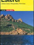 Maures – Esterel Didier Richard 15
 Mont Blanc Rando Editions
 Tour du Mont Blanc L`Escursionista Editore Map-Guide
 Massif du Mont Blanc IGN Wall Map
 Mont Blanc Massif IGC 4
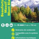 Beaufortain – Massif du Mont Blanc IGN 75004
 Mountaineering in the Mont Blanc Range: Classic Snow, Ice & Mixed Climbs
 Mont Blanc – Chamnonix – Courmayeur – Grand St-Bernard Swisstopo SKI 292S
 Mont-Blanc – A Walker`s Guide
 Lake Geneva and Mont Blanc IGN 75007
 Mont Blanc Supercracks
 Tour du Mont Blanc: including Chamonix, Courmayeur and Argentiere
 Tour du Mont-Blanc IGN 89025
 Mont Blanc 4810m – 5 Routes to the Summit
 Mont Blanc: The Finest Routes
 Chamonix – Rockfax: A Guide to the Best Rock Climbs and Mountain Routes Around Chamonix and Mont-Blanc
Mont Blanc Granite: a rock climbing guide
Chamonix – Rockfax: A Guide to the Best Rock Climbs and Mountain Routes Around Chamonix and Mont-Blanc
Mont Blanc Granite: a rock climbing guide
 Trekking the Tour of Mont Blanc: Complete two-way hiking guidebook and map booklet
 Selected Climbs: Mont Blanc & the Aiguilles Rouges: 60 Rock Routes from F4 to F6a+
 Mont Blanc: Classic & Plaisir
 Mont Blanc Walks
 Tour du Mont Blanc: The most iconic long-distance, circular trail in the Alps with customised itinerary planning for walkers, trekkers, fastpackers and trail runners
 Du Lรฉman ร la Vanoise – par le Mont Blanc et le Beaufortain GR5
 Tour du Mont Blanc – Easy-to-use Folding Map and Essential Information
 Mont Blanc Massif (Vol.I): Selected Climbs
 Tour du Mont Blanc: The World`s most famous trek – everything you need to know to plan and walk it
 Mont Blanc – Grand Combin Swisstopo 5003