Disclosure : This site contains affiliate links to products. We may receive a commission for purchases made through these links.
Greece Michelin
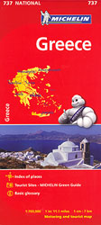
Indexed road map of Greece at 1:700,000 from Michelin for route-planning. Clear and easy-to-read cartography shows motorways, junctions and interchanges, dual carriageways, with distances (total and intermediate) marked; some local roads are also displayed, as are steep slopes and toll sections. Railways, cable-cars, airports, ferry and boat lines are also highlighted, with seasonal services in bold red colouring. Major towns, cities, and seas are marked with names in both Latin and Greek alphabets.Major topography is indicated with simple relief shading and selected spot heights. Woodland & forest is marked with green shading. National and administrative divisions are marked, as are administrative capitals. Selected sights such as historic castles, religious buildings and ruins are shown, as well as national parks.A quick-reference chart of distances & driving times between major locations is also included, as well as a quick reference panel giving national driving regulations, including speed limits, equipment requirements (e.g. bulb kits, warning triangles) and seatbelt rules, for all countries principally shown.There is also an index of principal place names grid-referenced to the map.

Related Products:
 Romania Michelin
 Hungary Michelin
 Slovenia – Croatia – Bosnia-Herzegovina – Serbia – Montenegro – North Macedonia Michelin
 Poland Michelin
 Finland Michelin
 Portugal – Madeira Michelin
 Norway Michelin
 Austria Michelin
 Czechia Michelin
 Sweden Michelin
 Czechia – Slovakia Michelin
 Czechia – Slovakia Michelin SUPERCEDED
 Baltic States Michelin
 Latvia Regio Manors and Palaces
 Greece 700K F&B
 Ivory Coast Michelin
 Greece Anavasi Road Map
 Greece: Attika and Central Greece Road Atlas
 Turkey Michelin
 Mexico Michelin
 Crete Michelin
 Poland`s Tourist Attractions Map
 Greece: Terrain Editions 150K Road Maps of Crete
 China East ITMB
 Chile – Argentina Michelin
 Northern England – Midlands Michelin Regional 502
 Germany North F&B
 Turkey – Middle East Road Map
 Turkey – Europe Road Map
 France North F&B
 Germany South F&B
 Cuba Michelin
 Wales – South West England – Midlands Michelin Regional 503
 France South F&B
 Venezuela F&B
 Great Britain: Michelin 400K Road Maps
 Texas – Oklahoma Michelin Zoom 176
 Romania – Moldova F&B
 USA Michelin