Disclosure : This site contains affiliate links to products. We may receive a commission for purchases made through these links.
Haida Gwaii (Queen Charlotte) Islands
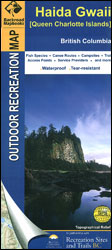
Haida Gwaii (Queen Charlotte) Islands at 1:200,000 on a large, contoured map from Mussio Ventures, printed on light, waterproof and tear-resistant plastic paper, with notes on recreational activities and sites, etc.The map is double-sided, covering on one side Graham Island, with Moresby and the southern islands on the reverse. Skidegate Inlet and the area around Sandspit and Queen Charlotte are shown on an enlargement at 1:100,000. Contours are at 20m interval with additional relief shading. Very detailed grading of the road network includes classifications for 2WD or 4WD industry roads. Symbols indicate various types of campsites and caravan parks, trail heads, wildlife viewing locations, etc. Larger lakes are notated to show what species of fish can be found there. The map has a UTM grid. Each side has a separate extensive index. Also included are lists of activities available in the local provincial parks and recreational sites, plus advertisements for various local services, cross-referenced to their locations on the map.


