Disclosure : This site contains affiliate links to products. We may receive a commission for purchases made through these links.
Mid-Wales North Sustrans Cycle Map 23
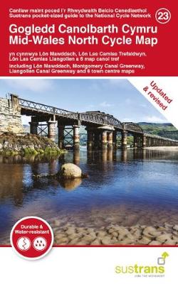
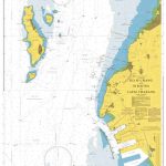
This area map shows the National Cycle Network and local routes in this area. It covers the northern area of the Mid Wales region of Wales, including Aberwystwyth, Machynlleth, Llangollen and southern Snowdonia.With landscape ranging from the uplands of the Cambrian mountains and Snowdonia to picturesque views over Cardigan Bay, north mid-wales offers a great variety of cycling experiences from traffic-free paths to challenging gradients. Head south from Porthmadog through stunning South Snowdonia, until you reach Coed Y Brenin forest park, Wales` home of mountain biking, or explore the Centre for Alternative Technology in Machynlleth. This pocket-sized colour map shows clearly mapped on-road and traffic-free paths, easy to read contours, and detailed inset maps for the major towns and cities as well as recommended linking routes connecting the NCN with quiet roads. MAJOR ROUTES COVERED BY THIS MAP:National Route 8 (Lon Las Cymru cycle route) between Llanidloes and Criccieth via Machynlleth, Dolgellau, the Mawdach Trail and Porthmadog.National Route 81 (Lon Cambria cycle route / Montgomery Canal Greenway) between Welshpool and Llanidloes via Newtown.National Route 82 between Machynlleth and Porthmadog via Tywyn, Dolgellau and Coed Y Brenin.National Route 85 (Llangollen Canal route) between Llangollen and Chirk.Regional Routes 12, 13, 14, 15 and 16 around Y Bala.Regional Routes 41, 42 and 43 around the Llyn Peninsula.

Related Products:
 North Wales – Lon Eifion – Lon Las Cefni – North Wales Coast Route Sustrans Cycle Map 24
 Mid-Wales South Sustrans Cycle Map 14
 South West Wales 110K Sustrans Cycle Map No. 13
 Lรดn Las Cymru North Sustrans Cycle Route Map
 South East Wales – Taff Trail – Celtic Trail – Lon Las Cymru – 3 Parks Trail Sustrans Cycle Map 12
 Central Sussex & South Surrey Sustrans Cycle Map 7
 Lancashire Sustrans Cycle Map 30
 South Cumbria & The Lake District Sustrans Cycle Map 31
 Bath to Bournemouth Sustrans Cycle Route Map
 North York Moors, Tees Valley & Durham Coast Sustrans Cycle Map 33
 Celtic Trail Sustrans Cycle Route Map
 Derry ~ Londonderry & The North West Cycle Map 51 sustrans
 Lรดn Las Cymru South Sustrans Cycle Route Map
North Northumberland & Scottish Borders Sustrans Cycle Map 39
Lรดn Las Cymru South Sustrans Cycle Route Map
North Northumberland & Scottish Borders Sustrans Cycle Map 39
 Cycling Lon Las Cymru: 250 miles through the heart of Wales on traffic-free paths and quiet roads
 North Cumbria & Dumfries 110K Sustrans Cycle Map No. 35
 Lรดn Las Cymru Cycle Route North: Holyhead – Llanidloes
 Land`s End to John O`Groats – On the National Cycle Network: Official Sustrans Guide
County Durham & North Yorkshire Sustrans Cycle Map 32
Land`s End to John O`Groats – On the National Cycle Network: Official Sustrans Guide
County Durham & North Yorkshire Sustrans Cycle Map 32
 South Cambridgeshire, Bedfordshire & North Hertfordshire 110K Sustrans Cycle Map No. 17
 The Bay Cycle Way Sustrans Cycle Route Map
 Devon North Sustrans Cycle Map 3 – Including the Tarka Trail
 Warwickshire & South Midlands 110K Sustrans Cycle Map No. 16
 Dundee, Angus & North Fife 110K Sustrans Cycle Map No. 44
 Lochs & Glens North Cycle Route
 Suffolk – Ipswich – Bury St Edmunds – Felixstowe – Suffolk Coast Cycle Route Sustrans Cycle Map 18
Cornwall Sustrans Cycle Map 1 – The Camel Trail – Clay Trails – Mineral Tramways
Suffolk – Ipswich – Bury St Edmunds – Felixstowe – Suffolk Coast Cycle Route Sustrans Cycle Map 18
Cornwall Sustrans Cycle Map 1 – The Camel Trail – Clay Trails – Mineral Tramways
 Fermanagh Lakelands & Tyrone Cycle Map 50 Sustrans
 Tyne & Wear Sustrans Cycle Map 34 – incl. the Sea to Sea, Hadrian`s Cycleway, Reivers Route
 Pennine Cycleway South Sustrans Cycle Route Map
 Glasgow – Stirling & the Clyde Sustrans Cycle Map 41
 Lanarkshire & Scottish Borders 110K Sustrans Cycle Map No. 38
 Merseyside & Manchester – Pennine Cycleway – The Trans Pennine Trail Sustrans Cycle Map 25
 Lรดn Cambria & Lรดn Teifi: Mid-Wales Cycle Routes
 North Wales and Snowdonia
 The Causeway Coast & Glens Cycle Map 52 Sustrans
 Herefordshire, Worcestershire & North Gloucestershire 110K Sustrans Cycle Map No. 15
 Traffic-Free Cycle Trails: The essential guide to over 400 traffic-free cycling trails around Great Britain
 Wales Coast Path Official Guide 4: Snowdonia & Ceredigion Coast: Porthmadog to Cardigan