Disclosure : This site contains affiliate links to products. We may receive a commission for purchases made through these links.
Western Lycia – Fethiye to Kalkan
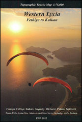
The western coast of Lycia, from Fethiye to east of Kalkan on a contoured and GPS compatible map from EWP, highlighting local hiking trails including the Lycian Way. Contours are at 40m intervals with colouring for woodlands. Cartography is based on the Soviet military maps of the area and the current edition of the map published in 2013 is annotated by the publishers:’This map is based on Soviet Military Maps for the topography, much of the contouring and the green forest area markings are inaccurate. All other information has been added and checked using local mapping sources, Google Earth and a considerable amount of on-the-ground research by several teams of people.”Road network indicates unsurfaced roads or 4WD tracks and locations of petrol stations. The map shows waymarked hiking trails, including the course of the Lycian Way. Symbols mark various landmarks and places of interest. Latitude and longitude lines are drawn at 5’intervals. Map legend is in English, German and Turkish. On the reverse is a list of useful addresses, a trilingual glossary, plus colour photos.PLEASE NOTE: the adjoining map of Central Lycia from EPW, extending coverage further east to Finike, has clearer, more modern cartography providing an excellent presentation of the terrain.


