Disclosure : This site contains affiliate links to products. We may receive a commission for purchases made through these links.
Cycling Northern France: Cycle Routes North of the Loire
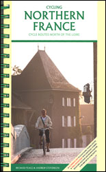
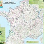
Cycling Northern France: Cycle Routes North of the Loire, an A5, spiral-bound guide-and-map set from Excellent Books with eight touring routes, plus over 5000km of greenways and vรฉloroues, all with detailed descriptions and extracts from Michelin maps at 1:200,000, plus a separate folded map printed on light, waterproof and tear-resistant synthetic paper.The 265-page guide is divided into three sections. Eight long-distance touring routes have detailed descriptions, with each day stage accompanied by information on recommended accommodation and bike shops, plus a km-by-km route profile. The relevant mapping for the whole route, including street plan extracts for the urban sections, is provided on the fold-out map.The second section, arranged by administrative regions, offers in each area a selection of day routes, with an overview map of the region indicating their locations. Map extracts are next to the descriptions and the overprint on them indicates sealed or unsealed greenways (Voie Verte), signposted road routes (Vรฉloroues), and intersections with other recommendations in the guide. For routes starting in the capital, the folded map also includes a street plan of central Paris indicating the city’s Avenue Verte routes.The guide includes a biking glossary and its introductory section offers general advice on cycling in France. For more detailed mapping for cycling in France the guide recommends IGN’s 1:100,000 TOP 100 series which show more minor local roads and provides a better picture of the terrain through contours, etc. Both Michelin maps and the more detailed IGN maps are all listed on Stanfords’ website.


