Disclosure : This site contains affiliate links to products. We may receive a commission for purchases made through these links.
White Peak Harvey British Mountain Map XT40
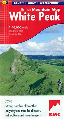
The White Peak area of the Peak District at 1:40,000 from Harvey Map Services printed on light, waterproof and tear-resistant synthetic paper, with on the reverse a geological map of the region, plus extensive advice on safety, first aid and map reading, useful contact addresses, etc.MAIN MAP: topography is shown by contours at 15m intervals, enhanced by light altitude colouring within the Open Access area, numerous spot heights, plus graphics and/or coloiring for different type of terrain and vegetation (boulder field, scree, rough pasture, scrub, woodland, etc). The map indicates different types of Right of Way paths and routes: public footpaths and bridleways with or without path on the ground, permissive paths, long-distance hiking paths, cycle routes and other right of way access. Symbols show locations of campsites and caravan sites, youth hostels and bunkhouses, public toilets, information offices, car parks and golf courses. The map has 1-km National Grid lines.GEOLOGICAL MAP: the geological map of the region at 1:100,000 is provided by the British Geological Survey and is accompanied by notes and a time chart.ADDITIONAL INFORMATION: the map also includes extensive notes on first aid basics, emergency procedures, hypothermia, map reading and symbols, and compass bearing, plus a list of useful contact details for accommodation, visitor information, etc.

Related Products:
 Dark Peak Harvey British Mountain Map XT40
 North York Moors Harvey British Mountain Map XT40
 Schiehallion – Ben Lawers & Glen Lyon Harvey British Mountain Map XT40
 Brecon Beacons Harvey British Mountain Map XT40
 Dartmoor Harvey British Mountain Map XT40
 Snowdonia South Harvey British Mountain Map XT40
 Cairngorms & Lochnagar Harvey British Mountain Map XT40
 Southern Highlands Harvey British Mountain Map XT40
 Yorkshire Dales Harvey British Mountain Map XT40
 Ben Nevis & Glen Coe Harvey British Mountain Map XT40
 Lake District Harvey British Mountain Map XT40
 Knoydart – Kintail & Glen Affric Harvey British Mountain Map XT40
 Snowdonia North / Gogledd Eryri Harvey British Mountain Map XT40
 Peak District South Harvey Ultramap XT40
Peak District North Harvey Ultramap XT40
Peak District Central Harvey Ultramap XT40
Peak District South Harvey Ultramap XT40
Peak District North Harvey Ultramap XT40
Peak District Central Harvey Ultramap XT40
 Great Britain: Harvey British Mountain Maps
Torridon & Fisherfield Harvey British Mountain Map XT40
Great Britain: Harvey British Mountain Maps
Torridon & Fisherfield Harvey British Mountain Map XT40
 Assynt & Coigach Harvey British Mountain Map XT40
 Peak District – Dark Peak A-Z Adventure Atlas
Speyside Way Harvey National Trail XT40
Peak District – Dark Peak A-Z Adventure Atlas
Speyside Way Harvey National Trail XT40
 Peak District South Harvey Superwalker XT25
 North Downs Way Harvey National Trail XT40
 Peak District North Harvey Superwalker XT25
West Highland Way Harvey National Trail XT40
Peak District North Harvey Superwalker XT25
West Highland Way Harvey National Trail XT40
 Peak District Central Harvey Superwalker XT25
 St Cuthbert`s Way Harvey National Trail XT40
 South Downs Way Harvey National Trail XT40
 Glyndwr`s Way Harvey National Trail XT40
 Shropshire Way Harvey National Trail XT40
 Dales Way Harvey National Trail XT40
Ridgeway Harvey National Trail XT40
Dales Way Harvey National Trail XT40
Ridgeway Harvey National Trail XT40
 Rob Roy Way Harvey National Trail XT40
 White Peak Mountain Biking: The Pure Trails
 Two Moors Way Harvey National Trail XT40
Cotswold Way Harvey National Trail XT40
Two Moors Way Harvey National Trail XT40
Cotswold Way Harvey National Trail XT40
 Cumbria Way Harvey National Trail XT40
Cleveland Way Harvey National Trail XT40
Cumbria Way Harvey National Trail XT40
Cleveland Way Harvey National Trail XT40
 Affric Kintail Way Harvey National Trail XT40
 Pembrokeshire Coast Path Harvey National Trail XT40