Disclosure : This site contains affiliate links to products. We may receive a commission for purchases made through these links.
Forest of Bowland
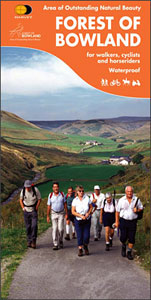
The Forest of Bowland Area of Outstanding Natural Beauty in northern Lancashire on a double-sided, waterproof and tear-resistant map from Harvey Map Services presenting on one side a wider area at 1:55,000, with on the reverse a more detailed map at 1:25,000, as indicated on our coverage image. The 55K map, aimed at cyclists and horse riders, has altitude colouring to show the topography, with spot heights and markings for steep road gradients. For cyclists, the map highlights eight cycling routes recommended by the publishers, other waymarked routes, plus shows the route numbers of the National Cycle Network. For horseriding, bridleways are highlighted and the course of the North Lancashire Bridleway Route. Also marked are long-distance hiking trails. A range of symbols indicate various facilities and places of interest, including campsites and caravan parks, youth hostels and bunkhouses, tearooms and pubs, shops, cycle hire, etc.On the reverse the central area is shown for walkers in greater detail, with contours at 15m intervals, numerous spot heights and colouring for different types of vegetation.. The map indicates right of way paths and bridleways. Both sides have the lines of the British National Grid.

Related Products:
 Forest of Bowland & Ribblesdale – Pendle Hill, Clitheroe & Settle OS Explorer Map OL41 (paper)
 Forest of Bowland & Ribblesdale – Pendle Hill, Clitheroe & Settle OS Explorer Active Map OL41 (waterproof)
 Walking in Lancashire: 40 walks throughout the county including the Forest of Bowland and Ribble Valley
 Lancashire Sustrans Cycle Map 30
 Forest of Bowland and Pendle Walking
 Glen Shiel & Kintail Forest – Shiel Bridge, Morvich, Killilan & Kinloch Hourn Forest OS Explorer Active Map 414 (waterproof)
 Charnwood Forest Regional Park
 Galloway Forest Park North – Glen Trool & Loch Doon St John`s Town of Dalry OS Explorer Active Map 318 (waterproof)
 Galloway Forest Park North – Glen Trool, Loch Doon & St John`s Town of Dalry OS Explorer Map 318 (paper)
 The Ultimate UK Cycle Route Planner
 Northumberland Official Cycle Touring Map
 Llandeilo & Brechfa Forest – Llanybydder OS Explorer Map 186 (paper)
 Wyre Forest & Kidderminster – Bridgnorth OS Explorer Map 218 (paper)
 Liddesdale & Kershope Forest – Newcastleton & Canonbie OS Explorer 324
 Sherwood Forest – Mansfield, Worksop & Edwinstowe OS Explorer Map 270 (paper)
 Wyre Forest & Kidderminster – Bridgnorth OS Explorer Active Map 218 (waterproof)
 Marlborough & Savernake Forest – Avebury & Devizes OS Explorer Map 157 (paper)
 Epping Forest & Lee Valley – Hertford & Harlow OS Explorer Map 174 (paper)
 Corby, Kettering & Wellingborough – Rockingham Forest OS Explorer Map 224 (paper)
 Llandeilo & Brechfa Forest – Llanybydder OS Explorer Active Map 186 (waterproof)
 Northwich & Delamere Forest – Winsford & Middlewich OS Explorer Map 267 (paper)
 Dumfries & Dalbeattie – New Abbey & Mabie Forest OS Explorer Map 313 (paper)
 Epping Forest & Lee Valley – Hertford & Harlow OS Explorer ACTIVE 174
 Liddesdale & Kershope Forest – Newcastleton & Canonbie OS Explorer 324 ACTIVE
 Sherwood Forest – Mansfield, Worksop & Edwinstowe OS Explorer Active Map 270 (waterproof)
 Corby, Kettering & Wellingborough – Rockingham Forest OS Explorer Active Map 224 (waterproof)
 Northwich & Delamere – Winsford & Middlewich Forest OS Explorer Active Map 267 (waterproof)
 Dumfries & Dalbeattie – New Abbey & Mabie Forest OS Explorer Active Map 313 (waterproof)
 Marlborough & Savernake Forest – Avebury & Devizes OS Explorer Active Map 157 (waterproof)
 John O`Groats & North Scottish Coast Cycle Map
 Nairn & Cawdor – Darnaway Forest, Ardersier & Culloden Muir OS Explorer Map 422 (paper)
 Nairn & Cawdor – Darnaway Forest, Ardersier & Culloden Muir OS Explorer Active Map 422 (waterproof)
 Eskdale & Castle O`er Forest – Langholm, Canonbie & Gretna Green OS Explorer Map 323 (paper)
 Eskdale & Castle O`er Forest – Langholm, Canonbie & Gretna Green OS Explorer Active Map 323 (waterproof)
 Thetford Forest in the Brecks – Thetford & Brandon OS Explorer Map 229 (paper)
 East Kilbride, Galston & Darvel – Loudoun Hill & Whitelee Forest OS Explorer Map 334 (paper)
 Thetford Forest in the Brecks – Thetford & Brandon OS Explorer Active Map 229 (waterproof)
 East Kilbride, Galston & Darvel – Loudoun Hill & Whitelee Forest OS Explorer Active Map 334 (waterproof)
 Ashdown Forest – Royal Tunbridge Wells, East Grinstead, Haywards Heath & Crowborough OS Explorer Map 135 (paper)
 Kielder Water & Forest – Bellingham & Simonside Hills OS Explorer Map OL42 (paper)