Disclosure : This site contains affiliate links to products. We may receive a commission for purchases made through these links.
Stafford 1879
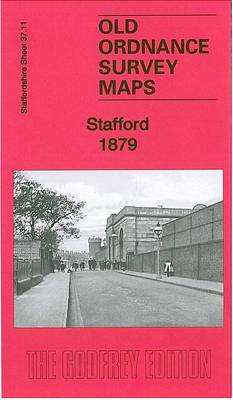
Stafford in 1879 in a fascinating series of reproductions of old Ordnance Survey plans in the Alan Godfrey Editions, ideal for anyone interested in the history of their neighbourhood or family. Two versions of this map have been published, showing how the area developed across the years. Coverage extends from the station eastward to Littleworth, and from Newport Road northward to Tillington Street. Features include LNWR railway with station and engine sheds, River Sow, Castle Engine Works, General Infirmary, Foregate area, Greengate Street area, St Mary`s church, Stafford Mill, The Green, cattle market, Green Hall, County Lunatic Asylum, Market Hall, Shire Hall, public baths, boot and shoe manufactory, County Industrial Home, Asylum Farm, Lammascote Farm, Littleworth, Cotonhill Asylum, Asylum sanitary wards, Coton Farm ,etc. The 1879 version also includes the LNWR Stafford-Shrewsbury-Welshpool timetable for 1897 on the reverse.About the Alan Godfrey Editions of the 25″ OS Series:Selected towns in Great Britain and Ireland are covered by maps showing the extent of urban development in the last decades of the 19th and early 20th century. The plans have been taken from the Ordnance Survey mapping and reprinted at about 15 inches to one mile (1:4,340). On the reverse most maps have historical notes and many also include extracts from contemporary directories. Most maps cover about one mile (1.6kms) north/south, one and a half miles (2.4kms) across; adjoining sheets can be combined to provide wider coverage.FOR MORE INFORMATION AND A COMPLETE LIST OF ALL AVAILABLE TITLES PLEASE CLICK ON THE SERIES LINK.

Related Products:
 Wolverhampton North West 1901
 Bescot 1901
 Lostock Hall and Farington North 1909
Glasgow High Street 1909
Glasgow High Street 1933
Lostock Hall and Farington North 1909
Glasgow High Street 1909
Glasgow High Street 1933
 Wavertree and Broad Green 1905
Hindley Green 1906
Wavertree and Broad Green 1905
Hindley Green 1906
 Stockton on Tees & Thornaby 1897 – 50.16a
Tamworth 1900
Ely 1901 – 26.14
Burnley 1910
Hall Green 1903
Stockton on Tees & Thornaby 1897 – 50.16a
Tamworth 1900
Ely 1901 – 26.14
Burnley 1910
Hall Green 1903
 Stafford and Telford 1833-1837
Winson Green and Hockley 1903
Winson Green and Hockley 1888
Stafford and Telford 1833-1837
Winson Green and Hockley 1903
Winson Green and Hockley 1888
 Bootle 1907
Wylde Green 1913
Earlestown South 1906
Maldon West 1920 – 55.16
Bootle 1907
Wylde Green 1913
Earlestown South 1906
Maldon West 1920 – 55.16
 Peckham 1894 – 103.2
 Peckham 1914 – 103.3
Ipswich 1902 – 75.11
Peckham 1871 – 103.1
Ipswich South-West 1902
Bamfurlong and Bryn Gates 1906
Peckham 1914 – 103.3
Ipswich 1902 – 75.11
Peckham 1871 – 103.1
Ipswich South-West 1902
Bamfurlong and Bryn Gates 1906
 Mossley Hill 1905
Bidston 1898
Duns & Greenlaw 1898 – 16.07
Kensal Green & West Kilburn 1865 – 47.1
Mossley Hill 1905
Bidston 1898
Duns & Greenlaw 1898 – 16.07
Kensal Green & West Kilburn 1865 – 47.1
 St Albans South-West 1897
Loughborough 1901
Brecon 1903 – 28.13
Kensal Green & Queen`s Park 1894 – 47.2
St Albans South-West 1897
Loughborough 1901
Brecon 1903 – 28.13
Kensal Green & Queen`s Park 1894 – 47.2
 Great Bridge and Toll End 1902
 Walsall (NE) 1913 – 63.07
 Hayes 1907
Cavan Town 1909
Hayes 1907
Cavan Town 1909
 Uckfield 1908
March Station 1900
Westhoughton 1907
Uckfield 1908
March Station 1900
Westhoughton 1907