Disclosure : This site contains affiliate links to products. We may receive a commission for purchases made through these links.
France: IGN 350K Touring Maps (2016 editions)
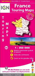
Touring maps of France at 1:350,000, 2016 editions, designed by the IGN to make route planning easier by presenting several regions together on one double-sided, indexed map which also includes enlargements showing environs of main cities.The Touring Series of four maps conveniently fills the gap between IGNโ€s general road maps presenting the whole country on one sheet and their Regional Series at 1:250,000 dividing France into its 19 administrative region. Colouring of the road network highlights the motorways, distinguishing between the toll and free sections and showing junction numbers, toll gates, services and rest areas, plus driving distances which are also marked on main connecting regional routes. The maps include other regional and selected smaller local roads. Railway lines are shown with stations and local airports are marked. Symbols indicate numerous places of interest.Topography is indicated by relief shading, with colouring for woodlands, boundaries of national/regional parks, and plenty of names of mountain ranges, valleys, peaks and other topographic features. The maps have no geographical coordinates, include a comprehensive index, and have English language map legend.Each title also includes several enlargements presenting in greater detail the environs of main cities, including road access to the town centre (please see descriptions of the individual titles).

Related Products:
 France: AA Regional Touring Maps
 France: IGN 200/250K Regional Maps
 Italy: Michelin 400K Touring Maps
 France: Michelin 500K Road Maps
France: IGN Maps of Environs of Main Cities
France: Michelin 500K Road Maps
France: IGN Maps of Environs of Main Cities
 France: Michelin 200K Regional Road Maps
 Greece: Terrain Editions 100K Touring Maps of Crete
 Australia: UBD Gregory`s Regional Road Maps
 USA: Reise Know-How Regional Touring Maps
 Latvia: Jana Seta 200K Regional Touring Maps
Norway: Cappelen Regional Road Maps
Latvia: Jana Seta 200K Regional Touring Maps
Norway: Cappelen Regional Road Maps
 Italy: Touring Club Italiano Regional Smart Maps
France: Michelin 150K Local Road Maps
Italy: Touring Club Italiano Regional Smart Maps
France: Michelin 150K Local Road Maps
 Poland: Reise-Know-How Touring Maps with Historic Place Names
 Italy: Touring Club Italiano 200K Regional Road Maps
 USA: Rand McNally Regional Maps
 Lithuania: Jana Seta 200K/250K Regional Touring Maps
 Italy: Kรผmmerly + Frey 200K Regional Road Maps
 Iceland: Mรกl og Menning Touring and Hiking Maps
France: Rando Editions/IGN 50K Walking Maps of the Pyrenees
Iceland: Mรกl og Menning Touring and Hiking Maps
France: Rando Editions/IGN 50K Walking Maps of the Pyrenees
 Greece: Anavasi Touring Maps of the Mainland and Peloponnese
 New Zealand: Kiwimaps 500K Touring Maps
 France: Rando Editions 50K Walking Maps of the French Alps
 France: IGN 150K Departmental Road Maps
 Norway: Norstedts Regional Road Maps
 Italy: Touring Club Italiano 400K Road Maps
 France Northeast Michelin
 France: IGN 75K/25K TOP75 Recreational Maps
 Spain: Michelin Regional Road Maps
 Argentina: Zagier & Urruty Regional Touring Maps
 France: Editions Benoit Wine Maps
 Pyrenees 350K Editorial Alpina Road Map
 France Southwest Michelin
 Spain: Reise Know-How Walking and Touring Maps of Mallorca
 France: Didier Richard Hiking Maps of South Eastern France and Corsica
 Portugal: Michelin Regional Road Maps
Italy Hallwag Road Map
Portugal: Michelin Regional Road Maps
Italy Hallwag Road Map