Disclosure : This site contains affiliate links to products. We may receive a commission for purchases made through these links.
Gota Channel Norstedts Cycling Map 19

Related Products:
 Blekinge Norstedts Cycling Map 05
Halland Norstedts Cycling Map 06
Oland Norstedts Cycling Map 10
Gotland Norstedts Cycling Map 11
Skane Southwest Norstedts Cycling Map 01
Skane Southeast Norstedts Cycling Map 02
Skane Northwest Norstedts Cycling Map 03
Skane Northeast Norstedts Cycling Map 04
Smaland Southwest Norstedts Cycling Map 07
Smaland Southeast Norstedts Cycling Map 08
Vastergotland – Goteborg Norstedts Cycling Map 12
Vastergotland South Norstedts Cycling Map 13
Smaland Northeast Norstedts Cycling Map 15
Bohuslan South Norstedts Cycling Map 17
Vastergotland North Norstedts Cycling Map 18
Sodermanland – Ostergotland Norstedts Cycling Map 22
Sodermanland East Norstedts Cycling Map 23
Varmland South Norstedts Cycling Map 24
Malaren East Norstedts Cycling Map 27
Roslagen North Norstedts Cycling Map 29
Siljan Surroundings Norstedts Cycling Map 30
Blekinge Norstedts Cycling Map 05
Halland Norstedts Cycling Map 06
Oland Norstedts Cycling Map 10
Gotland Norstedts Cycling Map 11
Skane Southwest Norstedts Cycling Map 01
Skane Southeast Norstedts Cycling Map 02
Skane Northwest Norstedts Cycling Map 03
Skane Northeast Norstedts Cycling Map 04
Smaland Southwest Norstedts Cycling Map 07
Smaland Southeast Norstedts Cycling Map 08
Vastergotland – Goteborg Norstedts Cycling Map 12
Vastergotland South Norstedts Cycling Map 13
Smaland Northeast Norstedts Cycling Map 15
Bohuslan South Norstedts Cycling Map 17
Vastergotland North Norstedts Cycling Map 18
Sodermanland – Ostergotland Norstedts Cycling Map 22
Sodermanland East Norstedts Cycling Map 23
Varmland South Norstedts Cycling Map 24
Malaren East Norstedts Cycling Map 27
Roslagen North Norstedts Cycling Map 29
Siljan Surroundings Norstedts Cycling Map 30
 Sweden: Norstedts 90K Cycling Maps
Smaland Coast South Norstedts Cycling Map 09
Vatter Lake South Norstedts Cycling Map 14
Smaland Coast North Norstedts Cycling Map 16
Dalsland – Bohuslan North Norstedts Cycling Map 20
Vattern Lake North Norstedts Cycling Map 21
Varmland East -Narke Norstedts Cycling Map 25
Malaren West – Hjalmaren Norstedts Cycling Map 26
Roslagen South – Stockholm Norstedts Cycling Map 28
Sweden: Norstedts 90K Cycling Maps
Smaland Coast South Norstedts Cycling Map 09
Vatter Lake South Norstedts Cycling Map 14
Smaland Coast North Norstedts Cycling Map 16
Dalsland – Bohuslan North Norstedts Cycling Map 20
Vattern Lake North Norstedts Cycling Map 21
Varmland East -Narke Norstedts Cycling Map 25
Malaren West – Hjalmaren Norstedts Cycling Map 26
Roslagen South – Stockholm Norstedts Cycling Map 28
 CHS Chart 6441 – West Channel including Anderton Channel, Ministicoog Channel and Moose Channel to Shoalwater Bay
 CHS Chart 6437 – Peel Channel including Husky Channel and Phillips Channel
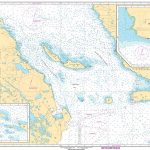
 Gota
Gota
 CHS Chart 6428 – Aklavik Channel to Napoiak Channel including Aklavik Channel to Aklavik Kilometre 1530-1597
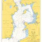 Instructional Chart 5130 – Irish Sea with Saint George`s Channel and North Channel
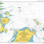 Admiralty Chart AUS292 – Adolphus Channel to Prince of Wales Channel
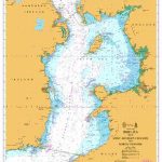 Admiralty Chart 1121 – Irish Sea with St George`s Channel and North Channel
 CHS Chart 7710 – Lambert Channel and Cache Point Channel
 NOAA Chart 17405 – Ulloa Channel to San Christoval Channel – North Entrance’”Big Salt Lake – Shelter Cove
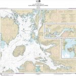
 Binnen 8 Gota kanal & Trollhate kanal