Disclosure : This site contains affiliate links to products. We may receive a commission for purchases made through these links.
West Hartlepool 1896 – 37.11b

Related Products:
 Stranton & Southern Hartlepool 1896 – 37.15
 West Hartlepool 1857-73 – 37.11a
West Hartlepool 1914 – 37.11c
West Hartlepool 1857-73 – 37.11a
West Hartlepool 1914 – 37.11c
 Poynton West 1896
 North West Gloucestershire 1896
 Hartlepool 1857 – 37.07a
 Hartlepool & East Durham 1913 – 27
 Hartlepool 1914 – 37.07c
 Middlesbrough, Darlington & Hartlepool OS Landranger Map 93 (paper)
 Middlesbrough, Darlington & Hartlepool OS Landranger Active Map 93 (waterproof)
 Admiralty Chart SC5615_4 – Whitby to Hartlepool – Runswick Bay
 Admiralty Chart SC5615_5 – Hartlepool to Tynemouth – Seaham
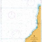
 Admiralty Chart 2566 – Tees and Hartlepool Bays
Newbiggin-by-the-Sea 1896 – 65.10
Admiralty Chart 2566 – Tees and Hartlepool Bays
Newbiggin-by-the-Sea 1896 – 65.10
 Torbay 1896 – 350
 Ferryhill 1896 – 35.10
 Middlesbrough & Hartlepool – Stockton-on-Tees & Redcar OS Explorer Map 306 (paper)
 Admiralty Chart SC5615_18 – Whitby Harbour – Hartlepool – Sunderland
 Esh & Ushaw College 1896 – 19.14
 Waltham Cross 1896 – 41.12
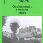 Oystermouth & Mumbles 1896 – 32.03
 South Derbyshire 1896 – 141
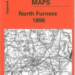 North Furness 1896 – 48
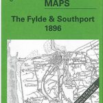 The Fylde & Southport 1896 – 66/74
 Sunderland (East) 1896 – 8.15
 Middlesbrough & Hartlepool – Stockton-on-Tees & Redcar OS Explorer Active Map 306 (waterproof)
 Willington (South) & Sunnybrow 1896 – 34.06
 Willington (North) & Oakenshaw 1896 – 34.02
 Scarborough – Filey & District 1896 – 54
 Malmesbury & the Southern Cotswolds 1896 – 251
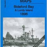 Bideford Bay & Lundy Island 1896 – 292/275
 Dulverton & The Brendon Hills 1896 – 294
 Bearsden 1896: Dumbartonshire Sheet 23.16
 Barrow-in-Furness & Walney Island 1896 – 58
 Salisbury Plain & Vale of Pewsey 1896 – 282
 Chard – Wellington & the Blackdown Hills 1896 – 311
 Ottery St Mary & the East Devon Coast 1896 – 326/340
 The Folk Who Live In The West: Tales from the West Coast
 Clydebank 1896
Motherwell 1896
Clydebank 1896
Motherwell 1896