Disclosure : This site contains affiliate links to products. We may receive a commission for purchases made through these links.
Scandinavia ITMB
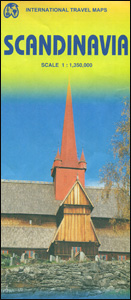
Scandinavia at 1:1,350,000 on an indexed map from ITMB, presenting on one side Denmark with southern Norway and Sweden, and on the reverse, with an overlap between the sides, northern Norway and Sweden with Finland. Road and rail networks are shown on a single-colour green background, with topography indicated only by spot heights. Also marked are selected ferry connections annotated with the duration of transit. Symbols indicate various places of interest and facilities; the map also shows national parks and restricted entry zones. Latitude and longitude lines are drawn at 1ยบ and 2ยบ respectively. Each side has a separate index.

Related Products:
 Finland – Northern Scandinavia Reise Know-How
 Scandinavia & Finland Michelin
 Wild Guide Scandinavia (Norway, Sweden, Iceland and Denmark)
 Seattle & Northwest USA ITMB
 Oslo / Bergen & South of Norway ITMB
 Lapland – Northern Scandinavia Karttakeskus
 Scandinavia – At War With Trolls
 Montreal & Southern Quebec ITMB
 Scandinavia Norstedts Wall Map
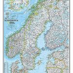 Scandinavia NGS Classic Wall Map PAPER
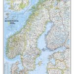 Scandinavia NGS Classic Wall Map LAMINATED
 Lonely Planet Scandinavia
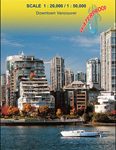 Vancouver & Greater Vancouver ITMB
 Malawi & Mozambique ITMB
 Tanzania ITMB
 Finland & Sweden ITMB
 Uganda ITMB
 Fodor`s Essential Scandinavia: The Best of Norway, Sweden, Denmark, Finland, and Iceland
 Bangkok & Thailand South ITMB
 Northern Europe – Scandinavia F&B
 Kilimanjaro & Tanzania North ITMB
 Alberta ITMB
 US Rocky Mountains ITMB
 Ghana ITMB
 Argentina South & Tierra del Fuego ITMB
 Canary Islands ITMB
 Chile South & Patagonia ITMB
Malta & Gozo ITMB
Chile South & Patagonia ITMB
Malta & Gozo ITMB
 Myanmar / Burma ITMB
 Cuba West ITMB
 Finland and Northern Scandinavia NGS Adventure Map 3300
 South America North ITMB
 Insight Guides Scandinavia
 USA Southwest ITMB
 Philadelphia & Mid-Atlantic States ITMB
 Baltic States ITMB
 Rome & Southern Italy ITMB
 Patagonia & Tierra del Fuego ITMB