Disclosure : This site contains affiliate links to products. We may receive a commission for purchases made through these links.
Sunshine Coast – Gibsons – Sechelt – Powell River BC
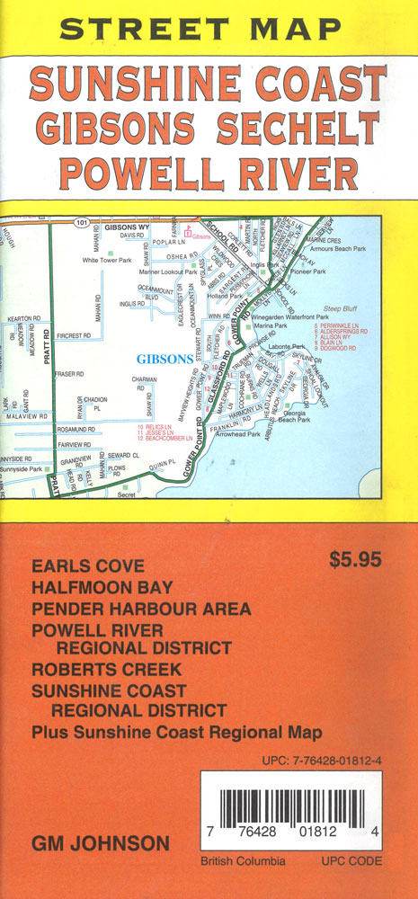
Covers Earl`s Cove, Halfmoon Bay, Pender Harbour Area, Powell River Regional District, Robert`s Creek, Sunshine Coast Regional District plus a Sunshine Coast regional map
Related Products:
 Vancouver Island – Sunshine Coast – Gulf Islands BC MapArt
 CHS Chart 3311 – Sunshine Coast, Vancouver Harbour to Desolation Sound
 Sunshine Coast QLD UBD Gregory`s 405
 Sunshine Coast – British Columbia Southwest ITMB
 The Jurassic Coast – Lyme Regis to Poole Harbour – Classic Walks – South West Coast Path
 The Sunshine Diet: Get Some Sunshine into Your Life, Lose Weight and Feel Amazing – Over 120 Delicious Recipes
 Luke Powell: Afghan Gold – Photographs 1973-2003
 Admiralty Chart SC5602_20 – Helford River – Helford River Continuation to Gweek – Continuation of River Fal. (Ruan Creek)
 Hood River OR Trail Map
 Admiralty Chart SC5600_4 – Lymington River – Continuation of Lymington River – Isle of Wight Yarmouth Harbour, River Yar
 Reg 6.1 Virginia & N Carolina Coast
 Wild Swimming Walks Cornwall: 28 coast, lake and river days out
 Admiralty Chart Folio 4 – West Coast of Ireland from Kenmare River to Bloody Foreland
 NOAA Chart 11553 – Intracoastal Waterway’”Albemarle Sound to Neuse River – Alligator River – Second Creek SUPERCEDED
 ADMIRALTY Leisure Folio SC 5623 – Ireland South West Coast
 Mecklenburg Coast and Lake District – Kiel – Hamburg – Rostock ADAC Regional Map 02
 Imray Chart C2: The River Thames
 C15 The Solent
 NOAA Chart 12248 – James River’”Newport News to Jamestown lsland – Back River and College Creek
 Admiralty Chart SC5615_17 – River Forth Grangemouth Roads – River Forth, Grangemouth and River Carron – River Forth River Carron
 Admiralty Chart SC5602_3 – River Fal Saint Just Pool to Truro River – Continuations of Truro River, Tresillian River and Carnon River
 Admiralty Chart 107 – East Coast, Approaches to the River Humber
 Admiralty Chart Folio 95 – East Coast of South America Cabo de Norte to Buenos Aires incl. the River, Uruguay and Parana
 Thunder and Sunshine: Riding Home from Patagonia
 Little Miss Sunshine
 NOAA Chart 16662 – Cook Inlet’”Kalgin Island to North Foreland – Drift River – Kasilof River to Kenai River – Nikiski
 Arkansas River – Leadville to Salida
 Admiralty Chart 1479 – Scotland ‘“ East Coast, River Tay, Dundee to Perth
 ADMIRALTY Leisure Folio SC 5617 – East Coast, Fife Ness to Inverness and the Caledonian Canal
 NOAA Chart 18661 – Sacramento and San Joaquin Rivers – Old River, Middle River and San Joaquin River extension – Sherman Island
 NOAA Chart 14829 – Geneva to Lorain (Metric) – Beaver Creek – Rocky River – Mentor Harbor – Chagrin River Harbor
 NOAA Chart 12347 – Hudson River Wappinger Creek to Hudson
 My Sunshine Away
 CEN304E Detroit River, Lake St.Clair, St.Clair River, 1996 – CHS Sailing Directions
 Wind River Range North Outdoor Recreation Map
 South Coast West Sustrans Cycle Route Map
 Admiralty Chart SC5602_7 – Fowey Harbour – River Fowey Mixtow to Saint Winnow – Continuation of River Fowey Saint Winnow to Lostwithiel
 A234 Northeast Coast of St Croix
 Coast to Coast – St Bees to Robin Hood’s Bay Harvey XT40 National Trail Map
 NOAA Chart 14826 – Moss Point to Vermilion – Beaver Creek – Rocky River – Vermilion Harbor


