Disclosure : This site contains affiliate links to products. We may receive a commission for purchases made through these links.
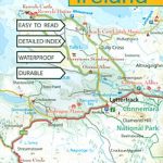
Ireland Adventure Map
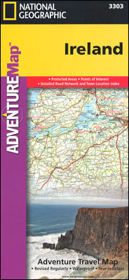
Ireland at 1:385,000 approx. in a series of Adventure maps from the National Geographic Society with cartography provided by Reise Know-How. The map is printed on light waterproof and tear-resistant synthetic paper and is double-sided, with Dublin and Galway included on both sides.Cartographic information provided by Reise Know-How has been adjusted to follow the house style of the NGS Adventure series, with contours at 50m intervals enhanced by relief shading. National parks and other protected areas are highlighted. Road network includes selected paved and improved roads and shows driving distances on main and secondary routes. Railway lines and ferry connections to Britain are included and local airports are marked. Also shown are county names and boundaries. Symbols indicate various places of interest including campsites, golf courses, etc. The map is indexed and has latitude and longitude lines at 20’ intervals.

Related Products:
 Italy NGS Adventure Map 3304
 Great Britain & Northern Ireland ReiseKnow-How Map
 Australia East Adventure Map
 Ireland Reise Know-How
 India Adventure Map
 Australia Adventure Map
 New Zealand Adventure Map
 Sardinia NGS Adventure Map 3309
 Spain – Portugal Adventure Map
 Cuba NGS Adventure Map 3112
 India Northeast NGS Adventure Map 3012
 India South Adventure Map
 Southern France Adventure Map
 Northern Spain NGS Adventure Map 3306
 Tuscany Adventure Map
 Sicily NGS Adventure Map 3310
 China East Adventure Map
 France Adventure Map
 Chile NGS Adventure Map 3402
 Brazil NGS Adventure Map 3401
 Slovenia Adventure Map
 Southern Sweden and Norway Adventure Map
 Finland and Northern Scandinavia NGS Adventure Map 3300
 China Adventure Map
 South Africa Adventure Map
 Argentina NGS Adventure Map 3400
 Morocco NGS Adventure Map 3203
 Vietnam North NGS Adventure Map 3015
 Vietnam South NGS Adventure Map 3016
 Thailand Adventure Map
 Ecuador – Galapagos NGS Adventure Map 3403
 Ireland: Exploreit Maps of Irish Counties
 Peru NGS Adventure Map 3404
 Nicaragua – Honduras – El Salvador NGS Adventure Map 3109
 Namibia Map Studio Adventure Map
 Great Britain – Ireland Michelin Pocket Map
 United Kingdom NGS Adventure Map 3325
 Egypt NGS Adventure Map 3202
 USA NGS Adventure Edition Road Atlas A3 SPIRAL-BOUND
 Germany Adventure Map