Disclosure : This site contains affiliate links to products. We may receive a commission for purchases made through these links.
Quรฉbec Province MapArt
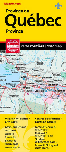
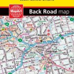
Quebec Province on an indexed, double-sided road map presenting its southern part in three panels. The main part of the province, from Montreal to Quebec City and Sherbooke, is covered at 1:500,000. Two further panels at 1:1,000,000 extend coverage further west and east: westward to the Ontario border and eastwards to Saguenay and Riviรจre-du-Loup (so including Ottawa, Montreal and Quebec City) and northwards to the Assinica Nature Reserve, plus further eastwards along the St. Lawrence River beyond Riviรจre-du-Loup to include the Gaspรฉ Peninsula and the northern coastline of the estuary.On the mapping at 1:500,000 and 1,000,000 road and rail networks are presented on a base with colouring highlighting national/provincial parks. Road network indicates paved, loose surface and unimproved roads, and shows driving distances on main and many local roads. Symbols show locations of campsites, visitor information centre, ski areas and various places of interest. The panels have no geographical coordinates and are covered by one combined index.Enlargements present in greater detail the environs of Montreal, Quebec City and Ottawa (all at 1:200,000) plus at more detailed scales Sanguenay, Trois-Riviรจres, Sherbrooke and Ramouski. Also provided is a map of the whole Quebec Province indicating northern locations accessible by air transport, plus a distance table.To see the list of currently available Canadian province and regional maps form the MapArt / Canadian Cartographics Corporation / JDM Gรฉo publishing group, including waterproof and tear-resistant FastTrack titles, please click on the series link.

Related Products:
 Quรฉbec Province FastTrack
 Quebec Province Pocket Road Atlas
 Quebec Province ITMB
Ontario MapArt
Quebec Province ITMB
Ontario MapArt
 Ontario Eastern MapArt
 Ontario MapArt Pocket Road Atlas
 Quebec Michelin 760
Quebec Province Road Atlas
Quebec Michelin 760
Quebec Province Road Atlas
 Montreal & Quebec City Pocket Precincts: A Pocket Guide to the City`s Best Cultural Hangouts, Shops, Bars and Eateries
 Quebec & Ontario ITMB Travel Atlas
 DK Eyewitness Top 10 Montreal and Quebec City
 Ottawa MapArt Street Plan
 Ontario Northern FastTrack Map: North Bay – Sudbury – Thunder Bay – Lake of the Woods
 Saskatchewan MapArt
 Canada MapArt Road Atlas
 Montreal & Southern Quebec ITMB
 New Brunswick MapArt
 Canada MapArt
 Ontario MapArt Back Road Atlas
 Atlantic Canada – New Brunswick – Nova Scotia – Prince Edward Island – Newfoundland
 Barcelona Province
 British Columbia MapArt
 Alberta MapArt Back Road Atlas
 Quebec MapArt Street Plan
 Montreal MapArt Street Plan
 Montreal – Ottawa F&B
 Alberta MapArt
 Southern Quebec ITMB
 Verona City and Province
 Manitoba & Saskatchewan MapArt Road Atlas
 Manitoba MapArt
 Nova Scotia MapArt
 British Columbia – Alberta MapArt
 Ontario South Central – Toronto – Niagara Falls – Kitchener-Wateroo Mapart Back Road Map
 Quebec City FastTrack
Vancouver Island – Sunshine Coast – Gulf Islands BC MapArt
Quebec City FastTrack
Vancouver Island – Sunshine Coast – Gulf Islands BC MapArt
 Cape Breton Island – Sydney – Truro NS MapArt
 Montreal & Quebec City Michelin Green Guide
 Canada – USA – Mexico Road Atlas
Canada: MapArt / Canadian Cartographics Corporation Provincial and Regional Road Maps and Atlases
Canada – USA – Mexico Road Atlas
Canada: MapArt / Canadian Cartographics Corporation Provincial and Regional Road Maps and Atlases