Disclosure : This site contains affiliate links to products. We may receive a commission for purchases made through these links.
Prince Edward Island ITMB
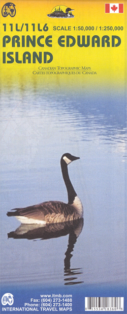
Prince Edward Island at 1:250,000, plus its central section at 1:50,00, with cartography from Natural Resources Canada, the national survey organization, and tourist overprint provided by the publishers, ITMB.On one side is Prince Edward Island at 1:250,000, including the nearby coast of New Brunswick and Nova Scotia. The island’s road network is shown on a contoured topographic base with colouring/graphics for different type of terrain and land cover. The map has a UTM grid, plus latitude and longitude margin ticks at 15’ intervals.On the reverse is a topographic map of the central part of the island, north of Charlottetown, at 1:50,000, with contours at 25 feet and a 1-km UTM grid. On both sides the publishers’ overprint highlight various types of accommodation including hotels, motels, lodges, campsites and RV grounds; tourist information centres; locations for recreational activities including fishing, horse riding, wind surfing, etc. The map is printed on paper.

Related Products:
 Nova Scotia & Prince Edward Island ITMB
 Moon Nova Scotia, New Brunswick & Prince Edward Island
 Nova Scotia and Prince Edward Island inc Iles de la Madeleine & Sable Island
 Prince Edward Island
 New Brunswick – Prince Edward Island FastTrack
 Lonely Planet Nova Scotia, New Brunswick & Prince Edward Island
 SHOM Chart 7604 – De Prince Edward Islands ร Heard Island – Iles Crozet , Kerguelen et Amsterdam
 Moon Atlantic Canada (Ninth Edition): Nova Scotia, New Brunswick, Prince Edward Island, Newfoundland & Labrador
 Atlantic Canada – New Brunswick – Nova Scotia – Prince Edward Island – Newfoundland
 Moon Atlantic Canada (Tenth Edition): Nova Scotia, New Brunswick, Prince Edward Island, Newfoundland & Labrador
 Fodor`s Nova Scotia & Atlantic Canada: With New Brunswick, Prince Edward Island, and Newfoundland
 Maritimes Provinces: New Brunswick – Nova Scotia – Prince Edward Island MapArt Back Road Atlas
CHS Chart 4925 – Harbours on the North Shore of Prince Edward Island
Maritimes Provinces: New Brunswick – Nova Scotia – Prince Edward Island MapArt Back Road Atlas
CHS Chart 4925 – Harbours on the North Shore of Prince Edward Island
 Frommer`s EasyGuide to Prince Edward Island, Nova Scotia and New Brunswick
 Admiralty Chart Folio 100 – Antarctic – Prince Edward, Crozet, Heard, McDonald & Kerguelen Islands
 Admiralty Chart 4712 – Iles Crozet to Prince Edward Islands
 Oahu, Honolulu & Big Island ITMB
 Christmas Island Cards – Edward Stanford (set of five)
 Easter Island & Santiago ITMB
 Vancouver Island ITMB
CHS Chart 5365 – Cap du Prince-De-Galles to Davies Island
Vancouver Island ITMB
CHS Chart 5365 – Cap du Prince-De-Galles to Davies Island
 NOAA Chart 17433 – Prince of Wales Island’”Kendrick Bay to Shipwreck Point
 The Black Prince
 Auckland & North Island ITMB
 NOAA Chart 17381 – Red Bay’”Prince of Wales Island
 Borneo / Kalimantan ITMB
 North Vancouver – Port Coquitlam ITMB
 The Happy Prince and Other Tales
 Prince William Sound West AK NGS Trails Illustrated Map 761
 The History of Mary Prince: A West Indian Slave
 NOAA Chart 17426 – Kasaan Bay’”Prince of Wales Island – Clark Bay – Hollis Anchorage (eastern part) – Lyman Anchorage
 Brabant Island to Adelaide Island
 Cuba ITMB
North Island – New Zealand ITMB
Cuba ITMB
North Island – New Zealand ITMB
 Brac Island
 In Line to the Throne: Prince Charles and the Other 29 in Waiting
 South Island – Northern & Central Kiwimaps
 Wolin Island – Wolinski National Park ExpressMap Tourist Map
 Jasper National Park & Northern Alberta ITMB
 The World Odyssey of a Balinese Prince