Disclosure : This site contains affiliate links to products. We may receive a commission for purchases made through these links.
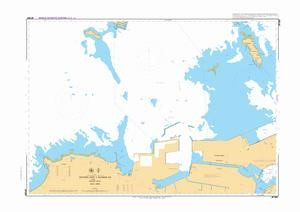
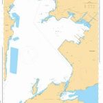
Admiralty Chart JP1267 – Nippon, Kyushu-North Coast & Seto Naikai, Western part of Kanmon Ko
Admiralty standard nautical charts comply with Safety of Life at Sea (SOLAS) regulations and are ideal for professional, commercial and recreational use. Charts within the series consist of a range of scales, useful for passage planning, ocean crossings, coastal navigation and entering port.

Related Products:
 Admiralty Chart JP1265 – Nippon, Seto Naikai & Kyushu-North Coast Kanmon Ko,Wakamatsu
 Admiralty Chart JP135 – Nippon, Seto Naikai, Kanmon Kaikyo
 Admiralty Chart JP1262 – Nippon, Seto Naikai, Eastern part of Kanmon Ko
Admiralty Chart JP1263 – Nippon, Seto Naikai, Middle part of Kanmon Ko
Admiralty Chart JP137B – Nippon, Seto Naikai, Western part of Bisan Seto
Admiralty Chart JP1247B – Nippon, Seto Naikai, Western Part of Oita Ko
Admiralty Chart JP134B – Nippon, Seto Naikai, Western Part of Himeji Ko
Admiralty Chart JP1127B – Nippon, Seto Naikai, Western Part of Mizushima Ko
Admiralty Chart JP1266 – Nippon, Kyushu-North and Honshu-Northwest Coasts, Kanmon Ko, Shirashima & Approaches
Admiralty Chart JP137A – Nippon, Seto Naikai, Eastern part of Bisan Seto
Admiralty Chart JP190 – Nippon, Kyushu-North Coast, Fukuoka Wan
Admiralty Chart JP1227 – Nippon, Kyushu-North Coast, Hakata Ko
Admiralty Chart JP179 – Nippon, Honshu-Northwest Coast & Kyushu-North Coast
Admiralty Chart JP201 – Nippon, Kyushu – North Coast & Honshu – Northwest Coast
Admiralty Chart JP1228 – Nippon, Kyushu-North Coast, Genkai Nada
Admiralty Chart JP153 – Nippon, Seto Naikai, Bisan Seto & Bingo Nada
Admiralty Chart JP106 – Nippon, Seto Naikai, Osaka Wan & Harima Nada
Admiralty Chart JP142 – Nippon, Seto Naikai, Hiroshima Wan
Admiralty Chart JP1120 – Nippon, Seto Naikai, Niihama Ko
Admiralty Chart JP1137 – Nippon, Seto Naikai, Fukuyama Ko
Admiralty Chart JP112 – Nippon, Seto Naikai, Naruto Kaikyo
Admiralty Chart JP132 – Nippon, Seto Naikai, Kurushima Kaikyo
Admiralty Chart JP141 – Nippon, Seto Naikai, Aki Nada and Approaches
Admiralty Chart JP1101 – Nippon, Seto Naikai, Suo Nada & Approaches
Admiralty Chart JP1102 – Nippon, Seto Naikai, Iyo Nada & Approaches
Admiralty Chart JP1127A – Nippon, Seto Naikai, Eastern Part of Mizushima Ko
Admiralty Chart JP129 – Nippon, Seto Naikai, Suo Nada, Kanda Ko
Admiralty Chart JP1108 – Nippon, Seto Naikai, Aki Nada & Hiroshima Wan
Admiralty Chart JP128 – Nippon, Seto Naikai, Suo Nada, Ube Ko
Admiralty Chart JP1262 – Nippon, Seto Naikai, Eastern part of Kanmon Ko
Admiralty Chart JP1263 – Nippon, Seto Naikai, Middle part of Kanmon Ko
Admiralty Chart JP137B – Nippon, Seto Naikai, Western part of Bisan Seto
Admiralty Chart JP1247B – Nippon, Seto Naikai, Western Part of Oita Ko
Admiralty Chart JP134B – Nippon, Seto Naikai, Western Part of Himeji Ko
Admiralty Chart JP1127B – Nippon, Seto Naikai, Western Part of Mizushima Ko
Admiralty Chart JP1266 – Nippon, Kyushu-North and Honshu-Northwest Coasts, Kanmon Ko, Shirashima & Approaches
Admiralty Chart JP137A – Nippon, Seto Naikai, Eastern part of Bisan Seto
Admiralty Chart JP190 – Nippon, Kyushu-North Coast, Fukuoka Wan
Admiralty Chart JP1227 – Nippon, Kyushu-North Coast, Hakata Ko
Admiralty Chart JP179 – Nippon, Honshu-Northwest Coast & Kyushu-North Coast
Admiralty Chart JP201 – Nippon, Kyushu – North Coast & Honshu – Northwest Coast
Admiralty Chart JP1228 – Nippon, Kyushu-North Coast, Genkai Nada
Admiralty Chart JP153 – Nippon, Seto Naikai, Bisan Seto & Bingo Nada
Admiralty Chart JP106 – Nippon, Seto Naikai, Osaka Wan & Harima Nada
Admiralty Chart JP142 – Nippon, Seto Naikai, Hiroshima Wan
Admiralty Chart JP1120 – Nippon, Seto Naikai, Niihama Ko
Admiralty Chart JP1137 – Nippon, Seto Naikai, Fukuyama Ko
Admiralty Chart JP112 – Nippon, Seto Naikai, Naruto Kaikyo
Admiralty Chart JP132 – Nippon, Seto Naikai, Kurushima Kaikyo
Admiralty Chart JP141 – Nippon, Seto Naikai, Aki Nada and Approaches
Admiralty Chart JP1101 – Nippon, Seto Naikai, Suo Nada & Approaches
Admiralty Chart JP1102 – Nippon, Seto Naikai, Iyo Nada & Approaches
Admiralty Chart JP1127A – Nippon, Seto Naikai, Eastern Part of Mizushima Ko
Admiralty Chart JP129 – Nippon, Seto Naikai, Suo Nada, Kanda Ko
Admiralty Chart JP1108 – Nippon, Seto Naikai, Aki Nada & Hiroshima Wan
Admiralty Chart JP128 – Nippon, Seto Naikai, Suo Nada, Ube Ko
 Admiralty Chart JP126 – Nippon, Seto Naikai, Tokuyama-Kudamatsu Ko and Approaches
Admiralty Chart JP104 – Nippon, Seto Naikai, Kurushima Kaikyo & Approaches
Admiralty Chart JP126 – Nippon, Seto Naikai, Tokuyama-Kudamatsu Ko and Approaches
Admiralty Chart JP104 – Nippon, Seto Naikai, Kurushima Kaikyo & Approaches
 Admiralty Chart JP1109 – Nippon, Seto Naikai, Hiroshima Wan, Kure Ko & Approaches
Admiralty Chart JP1247A – Nippon, Seto Naikai, Eastern Part of Oita Ko
Admiralty Chart JP165 – Nippon, Seto Naikai, Hiuchi, Misima- Kawanoe Ko
Admiralty Chart JP1133C – Nippon, Seto Naikai, Tokuyama-Kudamatsu Ko, Shin-Nan-Yo
Admiralty Chart JP1109 – Nippon, Seto Naikai, Hiroshima Wan, Kure Ko & Approaches
Admiralty Chart JP1247A – Nippon, Seto Naikai, Eastern Part of Oita Ko
Admiralty Chart JP165 – Nippon, Seto Naikai, Hiuchi, Misima- Kawanoe Ko
Admiralty Chart JP1133C – Nippon, Seto Naikai, Tokuyama-Kudamatsu Ko, Shin-Nan-Yo
 Admiralty Chart JP1220 – Nippon, Shikoku-South & Kyushu East Coast
Admiralty Chart JP1106 – Nippon, Seto Naikai, Tokuyama-Kudamatsu Ko,Tokuyama
Admiralty Chart JP1150 – Nippon, Seto Naikai, Wakayama-Shimotsu Ko, Wakayama
Admiralty Chart JP1248 – Nippon, Kyushu, South Coast, Kagoshima Wan, Kiire Ko
Admiralty Chart JP1144 – Nippon, Seto Naikai, Wakayama-Shimotsu Ko, Arida & Shimotsu
Admiralty Chart JP1220 – Nippon, Shikoku-South & Kyushu East Coast
Admiralty Chart JP1106 – Nippon, Seto Naikai, Tokuyama-Kudamatsu Ko,Tokuyama
Admiralty Chart JP1150 – Nippon, Seto Naikai, Wakayama-Shimotsu Ko, Wakayama
Admiralty Chart JP1248 – Nippon, Kyushu, South Coast, Kagoshima Wan, Kiire Ko
Admiralty Chart JP1144 – Nippon, Seto Naikai, Wakayama-Shimotsu Ko, Arida & Shimotsu